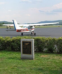
Hartness State Airport
| Hartness State Airport | |||||||||||||||
|---|---|---|---|---|---|---|---|---|---|---|---|---|---|---|---|

Hartness State Airport Tarmac, July 2008
|
|||||||||||||||
| Summary | |||||||||||||||
| Airport type | Public | ||||||||||||||
| Owner | State of Vermont | ||||||||||||||
| Serves | Springfield, Vermont | ||||||||||||||
| Elevation AMSL | 577 ft / 176 m | ||||||||||||||
| Map | |||||||||||||||
| Location of airport in Vermont / United States | |||||||||||||||
| Runways | |||||||||||||||
|
|||||||||||||||
| Statistics (1998) | |||||||||||||||
|
|||||||||||||||
|
Source: Federal Aviation Administration
|
|||||||||||||||
| Aircraft operations | 9,300 |
|---|---|
| Based aircraft | 37 |
Coordinates: 43°20′37″N 072°31′02″W / 43.34361°N 72.51722°W
Hartness State Airport (IATA: VSF, ICAO: KVSF, FAA LID: VSF) is a public airport located three miles (5 km) northwest of the central business district of Springfield, a town in Windsor County, Vermont, United States. It is owned by the State of Vermont.
Hartness State Airport covers an area of 185 acres (75 ha) which contains two asphalt paved runways: 5/23 measuring 5,498 x 100 ft (1,676 x 30 m) and 11/29 measuring 3,000 x 75 ft (914 x 23 m).
For the 12-month period ending November 20, 2012, the airport had 6,600 aircraft operations, an average of 127 per week: 95% general aviation, 3% air taxi and 2% military. There are 37 aircraft based at this airport: 76% single engine, 22% gliders and 3% multi-engine.
...
Wikipedia


