Harrison, Michigan
| Harrison, Michigan | |
|---|---|
| City | |

Looking southeast on Budd Lake
|
|
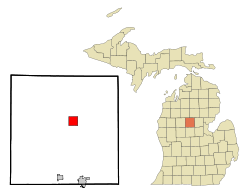
 Location of Harrison in Clare County, Michigan |
|
| Coordinates: 44°1′16″N 84°48′2″W / 44.02111°N 84.80056°W | |
| Country | United States |
| State | Michigan |
| County | Clare |
| Area | |
| • Total | 4.03 sq mi (10.44 km2) |
| • Land | 3.72 sq mi (9.63 km2) |
| • Water | 0.31 sq mi (0.80 km2) |
| Elevation | 1,165 ft (355 m) |
| Population (2010) | |
| • Total | 2,114 |
| • Estimate (2012) | 2,106 |
| • Density | 568.3/sq mi (219.4/km2) |
| Time zone | Eastern (EST) (UTC-5) |
| • Summer (DST) | EDT (UTC-4) |
| ZIP code | 48625 |
| Area code(s) | 989 |
| FIPS code | 26-36800 |
| GNIS feature ID | 0627850 |
| Website | http://www.cityofharrisonmi.org/ |
Harrison is a city in the U.S. state of Michigan. The population was 2,114 at the 2010 census. It is the county seat of Clare County.
The city is named after U.S. President William Henry Harrison.
Harrison is near the junction of US 127 and M-61. US 127 actually bypasses the city on the east, though a business route serves the downtown area. Clare is 14 miles (23 km) south on US 127, while Grayling is 40 miles (64 km) to the north. Harrison is bordered along its eastern side by Budd Lake.
Harrison was founded as a lumber town, with sawmills located on the shores of Budd Lake. One of the lumber companies donated the land which is now Wilson State Park. The City of Harrison attracts thousands of visitors from throughout the state, with its "twenty lakes in twenty minutes" and large amount of state land for recreational sports.
The biggest local events are the Clare County Fair and Frostbite Open Golf Tournament on Budd Lake.
There are several historic buildings in the city of Harrison. The Surrey House is a relic of the lumber town days. The Clare County Newspaper building, located downtown, is the oldest building in Harrison, dating back to 1898. Owners Rauch and Bucholz family gives tours of the Cleaver building, in addition to a walking tour of downtown Harrison.
According to the United States Census Bureau, the city has a total area of 4.03 square miles (10.44 km2), of which 3.72 square miles (9.63 km2) is land and 0.31 square miles (0.80 km2) is water.
As of the census of 2010, there were 2,114 people, 913 households, and 524 families residing in the city. The population density was 568.3 inhabitants per square mile (219.4/km2). There were 1,306 housing units at an average density of 351.1 per square mile (135.6/km2). The racial makeup of the city was 93.7% White, 1.7% African American, 0.8% Native American, 0.5% Asian, 0.2% from other races, and 3.1% from two or more races. Hispanic or Latino of any race were 2.5% of the population.
...
Wikipedia
