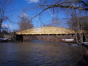
Hares Hill Road Bridge
| Hares Hill Road Bridge over French Creek |
|
|---|---|

Looking upstream (northwest)
|
|
| Carries | Single lane of SR 1045 in Chester County |
| Crosses | French Creek |
| Locale | Kimberton, Pennsylvania, and Phoenixville, Pennsylvania |
| Official name | SR 1045 Hares Hill Bridge |
| Other name(s) | Silver Bridge |
| Maintained by | PennDOT |
| ID number | 15104500201201 |
| Characteristics | |
| Design | wrought iron through lattice girder |
| Total length | 103 ft 4 in (31.50 m) |
| Width | 14 ft (4.3 m) |
| History | |
| Opened | 1869 |
| Statistics | |
| Daily traffic | approx. 4,000 |
|
Hare's Hill Road Bridge
|
|
| Nearest city | Phoenixville, Pennsylvania |
| Coordinates | 40°8′28″N 75°34′4″W / 40.14111°N 75.56778°WCoordinates: 40°8′28″N 75°34′4″W / 40.14111°N 75.56778°W |
| Area | 0.2 acres (0.08 ha) |
| Built | 1867 |
| Architectural style | Bow string truss |
| NRHP Reference # | 78002375 |
| Added to NRHP | March 28, 1978 |
The Hares Hill Road Bridge is a single-span, wrought iron, bowstring-shaped lattice girder bridge. It was built in 1869 by Moseley Iron Bridge and Roof Company and is the only known surviving example of this kind. The bridge spans French Creek, a Pennsylvania Scenic River, and connects the village of Kimberton and Spring City in Chester County, Pennsylvania. The structure has a current load posting of 7 tons (6.4 metric tons).
The Hares Hill Road Bridge superstructure consists of one 103 feet 4 inches (31.50 m) wrought-iron lattice girder span. The ends are supported on stone masonry abutments built by Abraham Taney, Jr., also in 1869. The bridge has been extensively rehabilitated several times, one of which added the current open grid steel deck.
The structure is listed in the National Register of Historic Places and has a high degree of historical and technological significance: it is the only known surviving example of Thomas William Moseley’s patented "Wrought Iron Lattice Girder Bridge." The bridge has been recorded by the Historic American Engineering Record (HAER) with detailed drawings, photographs, and a historical narrative. The structure carries one lane of traffic on Hares Hill Road (unsigned State Route 1045) across French Creek. Residences are located along the north bank of French Creek and a wooded area runs along the south bank.
The abutments are founded on rock and consist of random rubble mortared sandstone. They are 20 feet (6.1 m) long, 7 feet (2.1 m) wide at the base, have a batter of 1/2 inch per foot (1:24), and are about 12 feet (3.7 m) high above low water. Concrete pedestals have replaced the original stone-bearing seats. Wing walls extend approximately 60 feet (18 m) with a slight flare on the south side. The north wings are about 20 feet (6.1 m) long.
...
Wikipedia


