Harelbeke
| Harelbeke | |||
|---|---|---|---|
| Municipality | |||
 |
|||
|
|||
| Location in Belgium | |||
| Coordinates: 50°51′N 03°18′E / 50.850°N 3.300°ECoordinates: 50°51′N 03°18′E / 50.850°N 3.300°E | |||
| Country | Belgium | ||
| Community | Flemish Community | ||
| Region | Flemish Region | ||
| Province | West Flanders | ||
| Arrondissement | Kortrijk | ||
| Government | |||
| • Mayor | Alain Top (sp.a-Groen) | ||
| • Governing party/ies | sp.a-Groen, N-VA, Open Vld | ||
| Area | |||
| • Total | 29.14 km2 (11.25 sq mi) | ||
| Population (1 January 2016) | |||
| • Total | 27,536 | ||
| • Density | 940/km2 (2,400/sq mi) | ||
| Postal codes | 8530, 8531 | ||
| Area codes | 056 | ||
| Website | www.harelbeke.be | ||
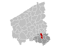
Harelbeke (West Flemish: Oarlbeke) is a municipality located in the Belgian province of West Flanders. The municipality comprises the city of Harelbeke proper and the towns of Bavikhove and Hulste. On January 1, 2006, Harelbeke had a total population of 26,172. The total area is 29.14 km² which gives a population density of 898 inhabitants per km². Inhabitants consider their hometown to be a "Weireldstad", which also led to a monthly "Harelbekedag" amongst the students of Harelbeke who are studying in Ghent
This cemetery is located just outside the downtown of Harelbeke and was designed by Willian Harrison Cowlishaw and contains the graves of 1126 Commonwealth soldiers who died during WWI (1055 from the UK, 26 from Canada, 7 from Australia, 4 from South Africa and 3 from Newfoundland). In addition 10 British soldiers who died during WWII are buried here.
Harelbeke has, since 1958, been the start and finish place of the E3 Harelbeke, a semi classic cycling race held the week before the Tour of Flanders.
Roundabout in Bavikhove decorated with artwork referring to (and sponsored by) the local Bavik Brewery
...
Wikipedia


