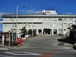
Hara, Nagano
|
Hara 原村 |
|||
|---|---|---|---|
| Village | |||

Hara Village Hall
|
|||
|
|||
 Location of Hara in Nagano Prefecture |
|||
| Coordinates: 35°57′51.8″N 138°13′2.6″E / 35.964389°N 138.217389°ECoordinates: 35°57′51.8″N 138°13′2.6″E / 35.964389°N 138.217389°E | |||
| Country | Japan | ||
| Region | Chūbu (Kōshin'etsu) | ||
| Prefecture | Nagano | ||
| District | Suwa | ||
| Area | |||
| • Total | 43.26 km2 (16.70 sq mi) | ||
| Population (October 2016) | |||
| • Total | 7,506 | ||
| • Density | 174/km2 (450/sq mi) | ||
| Time zone | Japan Standard Time (UTC+9) | ||
| Symbols | |||
| Phone number | 0266-79-2100 | ||
| Address | 6549-1 Hara-mura, Suwa-gun, Nagano-ken 391-0100 | ||
| Website | www |
||
Hara (原村 Hara-mura?) is a village located in Suwa District in northeast Nagano Prefecture, in the Chūbu region of Japan. As of 1 October 2016[update], the village had an estimated population of 7,506 and a population density of 174 persons per km². Its total area was 43.26 square kilometres (16.70 sq mi).
Hara is located in eastern Nagano Prefecture. The village is located in a mountainous area, and includes Mount Yatsugatake partly within its borders.
The area of present-day Hara was part of ancient Shinano Province. The modern village of Hara was established on April 1, 1889 by the establishment of the municipalities system.
The economy of Hara is based on agriculture.
Hara has one public elementary school and one public middle school operated by the village government. The village does not have a high school.
...
Wikipedia


