Hang East
| Hang East | |
|---|---|
| Wapentake | |

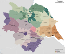
Wapentakes of North Yorkshire. Hang East is a dark green colour on the top left.
|
|
| History | |
| Subdivisions | |
| • Type | Nine parishes |
Hang East was a Wapentake (Hundred), which is an administrative division (or ancient district), in the historic county of the North Riding of Yorkshire. It was one of the smaller wapentakes by area and consisted of nine parishes and two towns; Bedale and Masham.
Its name derives from its meeting place of Hang Bank which was halfway between Hutton Hang and the village of Finghall. Hang is believed to derive from the Old English word Hangar which meant a wooded slope. The place is mentioned in the Domesday Book as Hotun. Both Hang East and Hang West, were originally one wapentake (Hang) until they were divided in the 13th century; this is why Hang East wapentake derives its name from a hill which was no longer in its area. Hang East was divided up into nine parishes; Bedale, Catterick, Hornby, Kirkby Fleetham, Masham, Patrick Brompton, Scruton, Thornton Watlass and Well.
It was bordered to the south by Claro Wapentake and to the east by Hallikeld and Gilling East Wapentakes. To the north lay Richmond and Gilling West Wapentake with Hang West on its western edge.
In 1831, the Wapentake was measured as covering 64,000 acres (26,000 ha) and was 8 miles (13 km) across at its widest and was 15 miles (24 km) from north to south. It was chiefly agricultural in nature and possessed two market towns; Bedale and Masham. Its land was described as being more fertile and low-lying than Hang West wapentake (to the west) which contained steeper valleys and higher peaks. In modern times, the area that the Wapentake covered is divided between the Hambleton and Richmondshire districts of North Yorkshire.
...
Wikipedia
