Thornton Watlass
| Thornton Watlass | |
|---|---|
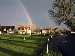
 Looking east across Thornton Watlass village green |
|
| Thornton Watlass shown within North Yorkshire | |
| Population | 224 (2011) |
| OS grid reference | SE235855 |
| District | |
| Shire county | |
| Region | |
| Country | England |
| Sovereign state | United Kingdom |
| Post town | RIPON |
| Postcode district | HG4 |
| Dialling code | 01677 |
| Police | North Yorkshire |
| Fire | North Yorkshire |
| Ambulance | Yorkshire |
| EU Parliament | Yorkshire and the Humber |
Thornton Watlass is a small village and civil parish within the Hambleton district of North Yorkshire, England. It is located north of Masham and south of Bedale on the eastern slopes of the Ure Valley at the entrance to Wensleydale and the Yorkshire Dales National Park. It is 11 miles North of Ripon, 4 miles from the A1, 11 miles from the main railway line at Northallerton and 18 miles from Teesside Airport. Its population was 180 in 200, 190 in 2005, and 224 in 2011.
The village lies at the junction of Watlass Lane and Watlass Moor Lane. At the centre of the village is the triangular village green with its trees, cricket pitch and children's playground, surrounded by houses, some of which are built from local stone. Thornton Watlass Church dates from the 11th century and the village also has a primary school and a public house called the Buck Inn. The village forms part of the Thornton Watlass Estate, and Thornton Watlass Hall, an ancient two-storey gabled stone house, lies just to the north of the village.
A prehistoric feature in the Thornton Watlass area is Gospel Hill tumulus, a Scheduled Ancient Monument, at grid reference SE228862 about 1 km northwest of the village.
...
Wikipedia

