Hancock County, MS
| Hancock County, Mississippi | |
|---|---|

Hancock County courthouse in Bay St. Louis
|
|
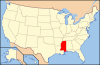
 Location in the U.S. state of Mississippi |
|
 Mississippi's location in the U.S. |
|
| Founded | 1812 |
| Named for | John Hancock |
| Seat | Bay St. Louis |
| Largest city | Bay St. Louis |
| Area | |
| • Total | 553 sq mi (1,432 km2) |
| • Land | 474 sq mi (1,228 km2) |
| • Water | 79 sq mi (205 km2), 14% |
| Population (est.) | |
| • (2015) | 46,420 |
| • Density | 93/sq mi (36/km2) |
| Congressional district | 4th |
| Time zone | Central: UTC−6/−5 |
| Website | www |
Hancock County is the southernmost county of the U.S. state of Mississippi. As of the 2010 census, the population was 43,929. Its county seat is Bay St. Louis. The county is named for Founding Father John Hancock.
Hancock County is part of the Gulfport–Biloxi-Pascagoula, MS Metropolitan Statistical Area. It is situated along the Gulf of Mexico and the state line with Louisiana. The area is home to the John C. Stennis Space Center, NASA's largest rocket engine test facility.
The county was severely damaged from Hurricane Katrina on August 29, 2005, causing catastrophic effects.
In 2005, the county was the scene of the final landfall of the eye of Hurricane Katrina, and its communities and infrastructure suffered some of the most intense damage inflicted by that storm. Over the entire 7-mile (11 km) beach front, not one building or home was left intact. This is true for nearly the entire 1st block off of the beach for the entire 7-mile (11 km) stretch.
Homes as far inland as 10 miles (16 km) were flooded by the historic storm surge which occurred during a full moon high tide. All rivers and waterways were inundated by the surge. Highway 603 south from Interstate 10 was completely submerged, and the Highway 90 - Bay St. Louis Bridge was left looking like a stack of dominoes.
...
Wikipedia
