Hammerbrook
| Hammerbrook | |
|---|---|
| Quarter of Hamburg | |

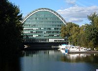
Berliner Bogen (Berlin Arch) office building
|
|
| Location of Hammerbrook within Germany | |
| Coordinates: 53°32′43″N 10°1′50″E / 53.54528°N 10.03056°ECoordinates: 53°32′43″N 10°1′50″E / 53.54528°N 10.03056°E | |
| Country | Germany |
| State | Hamburg |
| Borough | Hamburg-Mitte |
| Area | |
| • Total | 1.6 km2 (0.6 sq mi) |
| Population (2006-12-31) | |
| • Total | 435 |
| Area code(s) | 040 |
| Vehicle registration | HH |
Hammerbrook is a quarter (Stadtteil) in the Hamburg-Mitte borough of the Free and Hanseatic city of Hamburg in Germany. In 2006, the population was 435.
Hamm, as in the Hamm section of the city that borders it to the east, refers to forest, while brook refers to the low-lying swamp or carr that formerly characterised the area, which is the confluence of the Bille with the Elbe. The name Hammer Brook originally referred to the entire area east of the city and north of the Bille extending as far as Horn.
Hamburg acquired the area from the Counts of Holstein in 1383. From the 15th century onward it was administered by a Hamburg Senator as the Landherrenschaft (Lordship) of Hamm and Horn. It was used primarily as grazing land, and drainage ditches were gradually cut. A still surviving flood basin was created in the 17th century as part of the fortifications of the city. Settlement of the area began late in that century. In 1832 the western section was incorporated in the new suburb of St. Georg, while the rest was included in the Landherrenschaft of Geestlande. In 1871 this area was divided between Borgfelde and Hamm. The current quarter of Hammerbrook was administratively created in 1938 under the Greater Hamburg Act, although a section in the east became part of the then Hamm-Süd (South Hamm).
In 1840 the British engineer William Lindley proposed fully draining the area and using it for housing. After the Great Fire of Hamburg destroyed a third of the city in 1842, his plan was adopted: a grid of canals were dug, providing agricultural irrigation and also connecting the two rivers, and streets were then laid out, also on a grid pattern. Debris from the fire was used to raise the land. The district was rapidly populated as more people were displaced by slum clearance and the building of new public buildings in the decades after the fire; the new Hamburg-Bergedorf railway connected the area to the city. The population continued to grow as further slum clearance took place in the late 19th and early 20th centuries. Otto Stolten, elected from the district in 1901, was the first Socialist member of the Hamburg Parliament. In 1910 there were 60,000 inhabitants in Hammerbrook and surrounding areas, 40,000 within the borders of the modern quarter, they had themselves become overcrowded and unsanitary, and Hammerbrook was nicknamed Jammerbrook (Wailing Brook). In 1939 there were more than 27,000 inhabitants.
...
Wikipedia

