Hammer Field
| Fresno Yosemite International Airport | |||||||||||||||
|---|---|---|---|---|---|---|---|---|---|---|---|---|---|---|---|

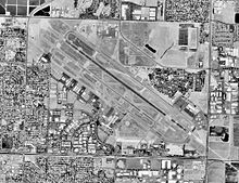
USGS aerial image, 1998
|
|||||||||||||||
| Summary | |||||||||||||||
| Airport type | Public / Military | ||||||||||||||
| Owner | City of Fresno | ||||||||||||||
| Operator | City of Fresno Airports Division | ||||||||||||||
| Serves | Fresno, California | ||||||||||||||
| Elevation AMSL | 336 ft / 102 m | ||||||||||||||
| Coordinates | 36°46′36″N 119°43′08″W / 36.77667°N 119.71889°WCoordinates: 36°46′36″N 119°43′08″W / 36.77667°N 119.71889°W | ||||||||||||||
| Website | www |
||||||||||||||
| Maps | |||||||||||||||
 Runway Diagram |
|||||||||||||||
| Runways | |||||||||||||||
|
|||||||||||||||
| Statistics (2015) | |||||||||||||||
|
|||||||||||||||
|
Source: Federal Aviation Administration
|
|||||||||||||||
| Aircraft operations | 15,412 |
|---|---|
| Passengers | 736,352 |
Fresno Yosemite International Airport (IATA: FAT, ICAO: KFAT, FAA LID: FAT), formerly Fresno Air Terminal, is a joint civil-military public airport in eastern Fresno, in Fresno County, California. Located approximately 64 miles south of Yosemite National Park on California State Route 41, it is the closest airfield to the Park with scheduled passenger airline jet service and is also located near two freeways being California State Route 168 and California State Route 180. The airport covers 2,150 acres (870 ha) and has two runways and one helipad. It is the air transport center for the San Joaquin Valley, with flights to several airline hubs in the western United States. International flights to Mexico are available through Aeroméxico and Volaris. It is also home to Fresno Air National Guard Base and the 144th Fighter Wing (144 FW) of the California Air National Guard.
The airfield opened in June 1942. During World War II the airfield was known as Hammer Field and was used by the United States Army Air Forces' Fourth Air Force. Hammer Field was a training base and had three sub-bases and two gunnery ranges.
...
Wikipedia


