Hamlin, New York
| Hamlin | |
| Town | |
|
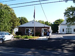
The post office for Hamlin, NY, located on Railroad Avenue
|
|
| Country | United States |
|---|---|
| State | New York |
| County | Monroe |
| Elevation | 345 ft (105.2 m) |
| Coordinates | 43°18′11″N 77°55′16″W / 43.30306°N 77.92111°WCoordinates: 43°18′11″N 77°55′16″W / 43.30306°N 77.92111°W |
| Area | 44.5 sq mi (115.3 km2) |
| - land | 43.4 sq mi (112 km2) |
| - water | 1.1 sq mi (3 km2), 2.47% |
| Population | 9,045 (2010) |
| Density | 208/sq mi (80.3/km2) |
| Established | 1852 |
| Town Supervisor | Eric Peters (R) First elected 2014
|
| Timezone | EST (UTC-5) |
| - summer (DST) | EDT (UTC-4) |
| ZIP code | 14464 |
| Area code | 585 |
|
Location in Monroe County and the state of New York.
|
|
|
Location of New York in the United States
|
|
| Website: http://www.hamlinny.org/ | |
Hamlin is a town in Monroe County, New York, United States. The population was 9,045 at the 2010 census.
The Town of Hamlin is in the northwest part of the county and is the second largest town in area in the county.
The Town of Hamlin was created as the "Town of Union," but was renamed in 1861 as the Town of Hamlin in honor of Lincoln's first Vice President Hannibal Hamlin.
Hamlin was initially a part of the town of Northampton. The town of Murray split from Northampton in 1807, and split again into Union and Clarkson on December 14, 1852.
The North Star School District No. 11 was listed on the National Register of Historic Places in 2014.
According to the United States Census Bureau, the town has a total area of 44.5 square miles (115 km2), of which, 43.4 square miles (112 km2) of it is land and 1.1 square miles (2.8 km2) of it (2.47%) is water.
The northern boundary is Lake Ontario and the western town line is the border of Orleans County, marked by New York State Route 272 (Monroe Orleans County Line Rd). The south town line borders the town of Clarkson, marked by Clarkson Hamlin Town Line Road that intersects Lake Road (New York State Route 19) south of Hamlin village. The eastern town line borders the town of Parma, marked by Hamlin-Parma Townline Road.
The Lake Ontario State Parkway passes across the north part of the town.
As of the census of 2000, there were 9,355 people, 3,255 households, and 2,532 families residing in the town. The population density was 215.5 people per square mile (83.2/km²). There were 3,503 housing units at an average density of 80.7 per square mile (31.2/km²). The racial makeup of the town was 96.78% White, 1.09% African American, 0.35% Native American, 0.32% Asian, 0.01% Pacific Islander, 0.68% from other races, and 0.76% from two or more races. Hispanic or Latino of any race were 1.60% of the population.
...
Wikipedia


