Hamburg-Poppenbüttel
| Poppenbüttel | |
|---|---|
| Quarter of Hamburg | |
| Coordinates: 53°39′33″N 10°5′5″E / 53.65917°N 10.08472°ECoordinates: 53°39′33″N 10°5′5″E / 53.65917°N 10.08472°E | |
| Country | Germany |
| State | Hamburg |
| City | Hamburg |
| Borough | Wandsbek |
| Area | |
| • Total | 8.1 km2 (3.1 sq mi) |
| Population (31.12.2016) | |
| • Total | 22,847 |
| • Density | 2,800/km2 (7,300/sq mi) |
| Time zone | CET/CEST (UTC+1/+2) |
| Dialling codes | 040 |
| Vehicle registration | HH |
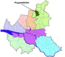
Poppenbüttel (![]() German pronunciation ) is a quarter in the borough Wandsbek of Hamburg, Germany. In 2016 the population was 22,847.
German pronunciation ) is a quarter in the borough Wandsbek of Hamburg, Germany. In 2016 the population was 22,847.
Poppenbüttel became a part of Hamburg in 1937. During World War II there were working locations for the subcamp Sasel of Neuengamme concentration camp in the quarter.
According to the statistical office of Hamburg and Schleswig-Holstein, the quarter has a total area of 8.1 km². To the northwest, Poppenbüttel borders on the state of Schleswig-Holstein and the quarter Lemsahl-Mellingstedt, in the east is the quarter Sasel. In the south is the quarter Wellingsbüttel and in the southwest is the quarter Hummelsbüttel.
Poppenbüttel lies on both sides of the Upper Alster river and is clearly separated from its neighbouring boroughs by uninhabited green zones and protected landscapes preserving wet and, in places, boggy depressions, and watercourses. In the west the Susebek depression and Raakmoor region separate Poppenbüttel from Langenhorn and Hummelsbüttel; in the northwest the meadows on the Poppenbütteler Graben mark the border with the Schleswig-Holstein borough of Norderstedt, in the north the Mellingbek and Kupferteich delineate its boundary with Lemsahl-Mellingstedt and in the south the Alster valley forms the boundary with Wellingsbüttel. In the east, some of the settlements cross over into Sasel, but in other places they are also separated by the Alster valley .
...
Wikipedia


