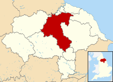
Hambleton District
| Hambleton District | ||
|---|---|---|
| District | ||
|
||
 Shown within North Yorkshire |
||
| Sovereign state | United Kingdom | |
| Constituent country | England | |
| Region | Yorkshire and the Humber | |
| Administrative county | North Yorkshire | |
| Admin. HQ | Northallerton | |
| Government | ||
| • Type | Hambleton District Council | |
| • Leadership: | Leader & Cabinet | |
| • Executive: | Conservative | |
| • MPs: |
Rishi Sunak, Kevin Hollinrake |
|
| Area | ||
| • Total | 506 sq mi (1,311 km2) | |
| Area rank | 14th | |
| Population (mid-2016 est.) | ||
| • Total | 90,500 | |
| • Rank | Ranked 266th | |
| • Density | 180/sq mi (69/km2) | |
| Time zone | Greenwich Mean Time (UTC+0) | |
| • Summer (DST) | British Summer Time (UTC+1) | |
| ONS code | 36UC (ONS) E07000164 (GSS) |
|
| Ethnicity | 99.2% White | |
| Website | hambleton.gov.uk | |
Coordinates: 54°20′02″N 1°25′44″W / 54.334°N 1.429°W
Hambleton is a local government district of North Yorkshire, England. The main town and administrative centre is Northallerton, and includes the market towns and major villages of Bedale, Thirsk, Great Ayton, Stokesley and Easingwold.
The district was formed by the Local Government Act 1972 on 1 April 1974, as a merger of the urban district of Northallerton with Bedale Rural District, Easingwold Rural District, Northallerton Rural District, and part of Thirsk Rural District, Stokesley Rural District and Croft Rural District, all in the North Riding of Yorkshire.
The district is named after the Hambleton Hills, part of the North York Moors National Park, on the eastern edge of the district. This area is the subject of a national habitat protection scheme as articulated in the United Kingdom's Biodiversity Action Plan.
...
Wikipedia

