Great Ayton
| Great Ayton | |
|---|---|
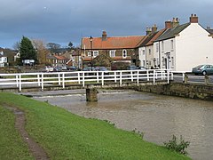
 Footbridge over the River Leven in Lower Green |
|
| Great Ayton shown within North Yorkshire | |
| Population | 4,629 |
| OS grid reference | NZ565115 |
| Civil parish |
|
| District | |
| Shire county | |
| Region | |
| Country | England |
| Sovereign state | United Kingdom |
| Post town | Middlesbrough |
| Postcode district | TS9 |
| Dialling code | 01642 |
| Police | North Yorkshire |
| Fire | North Yorkshire |
| Ambulance | Yorkshire |
| EU Parliament | Yorkshire and the Humber |
| UK Parliament | |
Great Ayton is a village and civil parish in the Hambleton district of North Yorkshire, England, on the edge of the North York Moors. It lies 7 miles (11.3 km) southeast of Middlesbrough and 3 miles (4.8 km) northeast of Stokesley on the border with the unitary authorities of Redcar and Cleveland and Middlesbrough. According to the 2011 Census, it has a population of 4,629.
The name Great Ayton derives from the Old English Ea-tun, tun meaning farm and ea meaning river.
In the 18th and 19th centuries Great Ayton was a centre for the industries of weaving, tanning, brewing, and tile making. Subsequently, whinstone was also quarried from the Cleveland Dyke.
It was home to the Great Ayton Friends' School (Quaker) from 1841 until it closed in 1997.
Great Ayton is at the foot of the Cleveland Hills beneath Easby Moor and the distinctively-shaped Roseberry Topping. The River Leven, a tributary of the River Tees, flows through the village and links its two centres, High Green and Low Green.
The Cleveland Dyke, a narrow band of hard whinstone rock that runs for about 31 miles between Robin Hood's Bay and Eaglescliffe lies to the north-east of the village.
An electoral ward of the same name exists. This ward stretches east to Kildale with a population taken at the 2011 census of 4,973.
...
Wikipedia

