Hamblen County, Tennessee
| Hamblen County, Tennessee | |
|---|---|

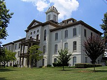
Hamblen County Courthouse in Morristown
|
|
|
Location in the U.S. state of Tennessee |
|
 Tennessee's location in the U.S. |
|
| Founded | 1870 |
| Named for | Hezekiah Hamblen |
| Seat | Morristown |
| Largest city | Morristown |
| Area | |
| • Total | 176 sq mi (456 km2) |
| • Land | 161 sq mi (417 km2) |
| • Water | 15 sq mi (39 km2), 8.3% |
| Population | |
| • (2010) | 62,544 |
| • Density | 388/sq mi (150/km²) |
| Congressional district | 1st |
| Time zone | Eastern: UTC-5/-4 |
| Website | www |
Hamblen County is a county located in the U.S. state of Tennessee. As of the 2010 census, the population was 62,544. Its county seat is Morristown.
Hamblen County is part of the Morristown, TN Metropolitan Statistical Area as well as the Knoxville-Morristown-Sevierville, TN Combined Statistical Area.
Hamblen County was created in 1870 from parts of Jefferson, Grainger, and Greene counties. The county is named in honor of Hezekiah Hamblen (1775–1854), an early settler, landowner, attorney, and member of the Hawkins County Court for many years. Governor Dewitt Clinton Senter, a resident of the county, used his influence to assist in its establishment.
According to the U.S. Census Bureau, the county has a total area of 176 square miles (460 km2), of which 161 square miles (420 km2) is land and 15 square miles (39 km2) (8.3%) is water. It is the third-smallest county in Tennessee by land area and fourth-smallest by total area.
As of the census of 2010, there were 62,544 people, 29,693 households, and 17,161 families residing in the county. The population density was 388 people per square mile (138/km²). There were 24,560 housing units at an average density of 153 per square mile (59/km²). The racial makeup of the county was 84.2% White, 10.7% Hispanic or Latino, 4% Black or African American, 0.3% Native American, 0.7% Asian, and 0.1% Pacific Islander.
...
Wikipedia
