Hakusan National Park
| Hakusan National Park | |
|---|---|
| 白山国立公園 | |
|
IUCN category II (national park)
|
|

|
|
| Location | Chūbu region, Honshū, Japan |
| Coordinates | 36°09′18″N 136°47′17″E / 36.15500°N 136.78806°ECoordinates: 36°09′18″N 136°47′17″E / 36.15500°N 136.78806°E |
| Area | 477 km2 (184 sq mi) |
| Established | 12 November 1962 |
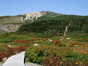
Hakusan National Park (白山国立公園 Hakusan Kokuritsu Kōen?) is a national park in the Chūbu region of Honshū, Japan. Established in 1962, it spans the borders of Fukui, Gifu, Ishikawa, and Toyama prefectures. Its main geographical feature is Mount Haku. In 1980 an area of 480 km² corresponding to the national park was designated a UNESCO Man and the Biosphere Reserve.
The park was originally designated Hakusan Quasi-National Park (白山国定公園 Hakusan Kokutei Kōen?), in 1955. It received full national park status in 1962.
The vegetation of the park ranges from warm temperate to alpine zones. The base of the mountains is covered by coniferous forests, dominated by firs, pines (Pinus aristata) and Japanese cedar. Deciduous forests and woodlands, dominated by Mongolian oak and Japanese beech are present. At higher elevations there are open landscapes.
...
Wikipedia
