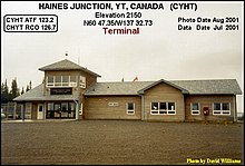
Haines Junction Airport
| Haines Junction Airport | |||||||||||
|---|---|---|---|---|---|---|---|---|---|---|---|
 |
|||||||||||
| Summary | |||||||||||
| Airport type | Public | ||||||||||
| Operator | Government of Yukon | ||||||||||
| Location | Haines Junction, Yukon | ||||||||||
| Time zone | PST (UTC−08:00) | ||||||||||
| • Summer (DST) | PDT (UTC−07:00) | ||||||||||
| Elevation AMSL | 2,150 ft / 655 m | ||||||||||
| Coordinates | 60°47′22″N 137°32′43″W / 60.78944°N 137.54528°WCoordinates: 60°47′22″N 137°32′43″W / 60.78944°N 137.54528°W | ||||||||||
| Map | |||||||||||
| Location in Yukon | |||||||||||
| Runways | |||||||||||
|
|||||||||||
Haines Junction Airport (IATA: YHT, ICAO: CYHT) is located 2 nautical miles (3.7 km; 2.3 mi) northwest of Haines Junction, Yukon, Canada. The airport has no scheduled airline service and is served by one fixed wing charter and two helicopter operators. Haines Junction is the gateway to Kluane National Park and Reserve. The airport is also the headquarters for the Yukon Governments Community and Transportation Services Airport Division.
...
Wikipedia

