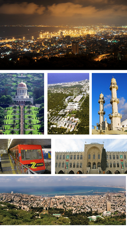
Haifa, Israel
Haifa
|
|||
|---|---|---|---|

From Upper left: View of Haifa at Night from Mount Carmel, Bahá'í World Centre, aerial view of the hi-tech park of Matam, Ahmadiyya Mahmood Mosque, The Carmelit, National Museum of Science, Technology, and Space, View of Haifa at day from Mount Carmel.
|
|||
|
|||
 Vector map of Haifa, Israel |
|||
| Vector map of Haifa, Israel | |||
| Coordinates: 32°49′0″N 34°59′0″E / 32.81667°N 34.98333°ECoordinates: 32°49′0″N 34°59′0″E / 32.81667°N 34.98333°E | |||
| Grid position | 145/246 PAL | ||
| Country |
|
||
| District | Haifa | ||
| Founded | 1st century CE | ||
| Government | |||
| • Type | City | ||
| • Mayor | Yona Yahav | ||
| Area | |||
| • City | 63,666 dunams (63.666 km2 or 24.582 sq mi) | ||
| Population (2015) | |||
| • City | 278,903 | ||
| • Urban | 600,000 | ||
| • Metro | 1,050,000 | ||
| Website | www |
||
Haifa (Hebrew: חֵיפָה Hefa [χei̯ˈfa, ˈχai̯fa]; Arabic: حيفا Hayfa), is the third-largest city in the State of Israel, with a population of 278,903 in 2015. The city of Haifa forms part of the Haifa metropolitan area, the second- or third-most populous metropolitan area in Israel. It is also home to the Bahá'í World Centre, a UNESCO World Heritage Site and a destination for Baha'i pilgrims.
Built on the slopes of Mount Carmel, the settlement has a history spanning more than 3,000 years. The earliest known settlement in the vicinity was Tell Abu Hawam, a small port city established in the Late Bronze Age (14th century BCE). In the 3rd century CE, Haifa was known as a dye-making center. Over the centuries, the city has changed hands: being conquered and ruled by the Phoenicians, Persians, Hasmoneans, Romans, Byzantines, Arabs, Crusaders, Ottomans, British, and the Israelis. Since the establishment of the State of Israel in 1948, the Haifa Municipality has governed the city.
...
Wikipedia


