Haidholzen
| Stephanskirchen | ||
|---|---|---|
|
||
| Coordinates: 47°51′N 12°11′E / 47.850°N 12.183°ECoordinates: 47°51′N 12°11′E / 47.850°N 12.183°E | ||
| Country | Germany | |
| State | Bavaria | |
| Admin. region | Oberbayern | |
| District | Rosenheim | |
| Government | ||
| • Mayor | Rainer Auer (SPD) | |
| Area | ||
| • Total | 26.51 km2 (10.24 sq mi) | |
| Elevation | 476-502 m (−1,171 ft) | |
| Population (2015-12-31) | ||
| • Total | 10,186 | |
| • Density | 380/km2 (1,000/sq mi) | |
| Time zone | CET/CEST (UTC+1/+2) | |
| Postal codes | 83071 | |
| Dialling codes | 08031, 08036 | |
| Vehicle registration | RO | |
| Website | www.stephanskirchen.de | |
Stephanskirchen is a municipality in the district of Rosenheim, Upper Bavaria in Germany.
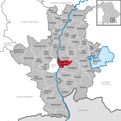
Stephanskirchen is located on a glacially formed plateau. The Inn river on the west and the lake Simssee are natural boundaries. The valley of the Sims river is a natural border at the south. North to Stephanskirchen are several forests and small lakes. The municipality is located within the Rosenheim-basin in the area of the former Inn-glacier. Therefore, numerous erratic boulders can be found here.
The municipality is by population the third largest in the district of Rosenheim and consists of 48 parts (Ortsteile). Major settlements are Schloßberg and Haidholzen. Further settlements are: Baierbach, Eckenholz, Eichbichl, Eitzing, Entleiten, Fussen, Gehering, Graben, Grasweg, Haiden, Hofau, Hofleiten, Hofmühle, Högering, Höhensteig, Innleiten, Kieling, Kleinholzen, Kohlhaufmühle, Kragling, Kreut, Kronstauden, Krottenhausmühle, Kuglmoos, Lack, Landl, Landlmühle, Lauterbacherfilze, Leiten, Leonhardspfunzen, Murnau, Neumühle, Oed, Pulvermühle, Puster, Reikering, Schömering, Sims, Simserfilze, Simssee, Sonnenholz, Stephanskirchen, Waldering, Weinberg, Westerndorf, Westerndorferfilze and Ziegelberg.
The emblem of Stephanskirchen was created in 1954 and indicates the historic dispartment: The holy Stephanus at the top symbolizes with his holy halo the area of Stephanskirchen. He holds a golden missal with tree golden stones in his left arm. The lower part of the emblem reminds of a dinghy, a so called "Mutze". This is because in the past the major source of income in Schloßberg, Hofleiten and close to the inn-shore was fishing and shipping. The dominant green color within the emblem points to the agricultural structure of Stephanskirchen.
The oldest traces were dated third and fourth century BC and can be found in the Doblergraben and at the Ziegelberg. An old Roman road crossed the River Inn at Leonhardspfunzen. The bridge was called "pons aeni" and headed westwards towards Augsburg. The first reports of a Christian church in the area around Sims are dated at 790 AD (ecclesia ad sinsa). Stephanskirchen was first mentioned in a record in the year 1130 where it was named "stevenchirgen". On the Schlossberg there was the Rosenheim castle which was first mentioned in the year 1234. It was used for administration and as a legal court of the Wittelsbacher; at the beginning of the 19th century it deteriorated.
...
Wikipedia


