Hafenlohr (river)
| Hafenlohr | |
| Lohrbach (historic) | |
| Creek | |
|
The Hafenlohr at Windheim
|
|
| Country | Germany |
|---|---|
| State | Bavaria |
| Region | Lower Franconia |
| District | Main-Spessart, Aschaffenburg |
| Tributaries | |
| - left | Mäusbach |
| - right | Tiergartenbach, Breitbach, Steinbach, Wachenbach |
| Source | Rothenbuch Castle |
| - location | Rothenbuch, Aschaffenburg, Germany |
| - elevation | 355 m (1,165 ft) |
| - coordinates | 49°58′3″N 9°23′52″E / 49.96750°N 9.39778°E |
| Mouth | Main |
| - location | Hafenlohr, Main-Spessart, Germany |
| - elevation | 142 m (466 ft) |
| - coordinates | 49°52′6″N 9°36′16″E / 49.86833°N 9.60444°ECoordinates: 49°52′6″N 9°36′16″E / 49.86833°N 9.60444°E |
| Length | 24.8 km (15 mi) |
| Basin | 147 km2 (57 sq mi) |
| Discharge | |
| - average | 1.74 m3/s (61 cu ft/s) |
| - max | 38.6 m3/s (1,363 cu ft/s) |
|
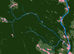
The Hafenlohr watershed
|
|
Hafenlohr is a creek of around 25 km length that discharges into the Main at the town of Hafenlohr. The Hafenlohr is located in the districts of Aschaffenburg and Main-Spessart in the Lower Franconia region of Bavaria, Germany.
The stream is known for its scenic valley, the Hafenlohrtal, and the eponymous nature preserve providing a habitat for many endangered plants and animals. In the past, for centuries the area was on the border between the territories of the Archbishop of Mainz and the Prince-Bishop of Würzburg. Past agricultural and industrial activities along the stream have been largely discontinued. Today, the area mainly offers recreation for hikers, bikers and other visitors. However, the Hafenlohr still feeds numerous ponds supporting fish farms and the forestry business of the nearby Fürstlich Löwensteinscher Park is located in the valley. A government project to turn most of the valley into a water reservoir by damming the Hafenlohr was abandoned in 2008 after decades of controversy.
The name Hafenlohr is derived from the Middle High German determiner word Havenaere (relating to Hafner or "potter"). Lohr is derived from the Celtic Lär meaning "broad" and "shallow". The creek gives the town Hafenlohr its name, which has for centuries been a centre of the pottery trade using locally found clay.
The Hafenlohrquelle (source) of the Hafenlohr river is in the village of Rothenbuch, next to the wall of Rothenbuch Castle (Schloss Rothenbuch). It was set in sandstone when the road ST2317 was broadened.
The Hafenlohr flows through the castle moat and after around 100 m joins the Tiergartenbach which at that point is already 1.6 km long. However, since this rivulet often carries no water at all during the summer, it is not generally considered the main tributary. Flowing south out of Rothenbuch, the Hafenlohr is next joined by the Breitenbach. The Hafenlohr then continues to the southeast and at the Ahlmichdamm it is joined by the Steinbach. It then turns east-north-east into a steep-sided valley without any larger settlements whose floor is the "Nature Preserve Hafenlohrtal". Before it reaches Rothenbuch-Lichtenau the Hafenlohr is joined near the small Eichensee by the Mäusbach coming from NNW. It then continues through the Lichtenauer Grund, passes several small ponds and reaches the "Nature Preserve Mainzer Eck" where the valley starts to meander. The hill Klosterkuppel (552 m) blocks the Hafenlohr's by now easterly course and it turns into its final direction towards the south east at Rothenbuch-Erlenfurt.
...
Wikipedia


