Hacienda Heights
| Hacienda Heights | |
|---|---|
| census-designated place | |

The view of Hacienda Heights, with Hsi Lai Temple and Puente Hills in the background
|
|
| Nickname(s): The Heights | |
| Motto: "Growing with Pride" | |
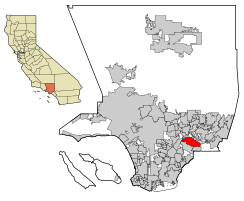
 Location of Hacienda Heights in Los Angeles County, California. |
|
| Location in the United States | |
| Coordinates: 34°0′2″N 117°58′10″W / 34.00056°N 117.96944°WCoordinates: 34°0′2″N 117°58′10″W / 34.00056°N 117.96944°W | |
| Country |
|
| State |
|
| County |
|
| Area | |
| • Total | 11.182 sq mi (28.962 km2) |
| • Land | 11.175 sq mi (28.944 km2) |
| • Water | 0.007 sq mi (0.018 km2) 0.06% |
| Elevation | 453 ft (138 m) |
| Population (2010) | |
| • Total | 54,038 |
| • Density | 4,800/sq mi (1,900/km2) |
| Time zone | PST (UTC-8) |
| • Summer (DST) | PDT (UTC-7) |
| ZIP code | 91745 |
| Area code(s) | 626, 562 |
| FIPS code | 06-31596 |
Hacienda Heights is an unincorporated suburban community and census-designated place in Los Angeles County, California, United States. As of the 2010 census, the community had a total population of 54,038, up from 53,122 at the 2000 census.
During Spanish rule, Hacienda Heights was a part of Rancho La Puente, which was operated by the nearby Mission San Gabriel Arcángel in San Gabriel. The Rancho was eventually acquired by John A. Rowland and William Workman in 1845 via a Mexican land grant, and eventually acquired by Elias "Lucky" Baldwin. In 1912, his descendant, Anita Baldwin, sold the property to Edwin Hart and Jet Torrance. The pair subdivided the area and named it North Whittier Heights, which became known for avocado, citrus and walnut orchards, in 1913. However, from the Great Depression era to the early 1940s, citrus growing became unprofitable because of pests and diseases, setting the impetus for the area's transformation into a suburb.
Originally an agricultural town, beginning in the 1940s and accelerating in the 1950s, suburban residential development, which occurred southward (beginning on subdivisions near Kwis Avenue), transformed Hacienda Heights into a residential or bedroom community. In 1961, the Hacienda Heights Branch of the Los Angeles County Public Library opened. The following year, in 1961, the area was renamed Hacienda Heights. In 1964, the local newspaper, the Hacienda Heights Highlander, was established.
...
Wikipedia

