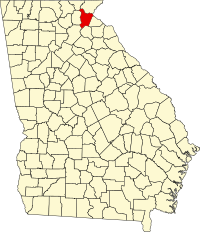
Habersham County
| Habersham County, Georgia | ||
|---|---|---|
|
||
 Location in the U.S. state of Georgia |
||
 Georgia's location in the U.S. |
||
| Founded | 1818 | |
| Named for | Joseph Habersham | |
| Seat | Clarkesville | |
| Largest city | Cornelia | |
| Area | ||
| • Total | 279 sq mi (723 km2) | |
| • Land | 277 sq mi (717 km2) | |
| • Water | 2.3 sq mi (6 km2), 0.8% | |
| Population | ||
| • (2010) | 43,041 | |
| • Density | 156/sq mi (60/km²) | |
| Congressional district | 9th | |
| Time zone | Eastern: UTC-5/-4 | |
| Website | www |
|
Habersham County is a county located in the U.S. state of Georgia. As of the 2010 census, the population was 43,041. The county seat is Clarkesville. The county was created on December 15, 1818, and named for Colonel Joseph Habersham.
Habersham County comprises the Cornelia, GA Micropolitan Statistical Area.
According to the U.S. Census Bureau, the county has a total area of 279 square miles (720 km2), of which 277 square miles (720 km2) is land and 2.3 square miles (6.0 km2) (0.8%) is water. The county includes part of Chattahoochee National Forest.
The highest point in the county is a 4,400-foot (1,300 m) knob less than 700 feet (210 m) southeast of the top of Tray Mountain, the seventh-highest mountain in Georgia. Habersham shares this portion of Tray Mountain, just 30 vertical feet shy of the peak's 4,430-foot summit, with White County to the west and Towns County to the north. 2.4 miles to the northeast of Tray Mountain is Young Lick (elevation 3,809 feet (1,161 m)). The Appalachian Trail runs along the top of the high ridge between Young Lick and Tray, a part of the Blue Ridge Mountain crest.
Habersham is mostly located in the Upper Chattahoochee River sub-basin of the ACF River Basin (Apalachicola-Chattahoochee-Flint River Basin), with the northeastern corner of the county located in the Tugaloo River sub-basin in the larger Savannah River basin, and the southeastern portion located in the Broad River sub-basin of the same Savannah River basin.
...
Wikipedia

