Haaksbergen
| Haaksbergen | |||
|---|---|---|---|
| Municipality | |||

Aerial view of Haaksbergen
|
|||
|
|||
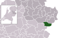
 Location in Overijssel |
|||
| Coordinates: 52°9′N 6°45′E / 52.150°N 6.750°ECoordinates: 52°9′N 6°45′E / 52.150°N 6.750°E | |||
| Country | Netherlands | ||
| Province | Overijssel | ||
| Government | |||
| • Body | Municipal council | ||
| • Mayor | vacant | ||
| Area | |||
| • Total | 105.50 km2 (40.73 sq mi) | ||
| • Land | 104.89 km2 (40.50 sq mi) | ||
| • Water | 0.61 km2 (0.24 sq mi) | ||
| Elevation | 27 m (89 ft) | ||
| Population (February 2017) | |||
| • Total | 24,397 | ||
| • Density | 233/km2 (600/sq mi) | ||
| Demonym(s) | Haaksbergenaar, Haaksberger | ||
| Time zone | CET (UTC+1) | ||
| • Summer (DST) | CEST (UTC+2) | ||
| Postcode | 7480–7489 | ||
| Area code | 053 | ||
| Website | www |
||
Haaksbergen (![]() pronunciation ) is a municipality and a town in the eastern Netherlands, in the province of Overijssel, in the Twente region.
pronunciation ) is a municipality and a town in the eastern Netherlands, in the province of Overijssel, in the Twente region.
The Buurserbeek flows through the municipality of Haaksbergen.
Dutch Topographic map of Haaksbergen (town), June 2014.
On 28 September 2014 a monster truck crashed in into the attending crowd. Three visitors were reported dead, amongst them one child. According to Hans Gerritsen, mayor of Haaksbergen at that moment, twelve people were injured.
...
Wikipedia


