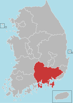
Gyeongsangnamdo
|
South Gyeongsang Province 경상남도 |
|||
|---|---|---|---|
| Province | |||
| Korean transcription(s) | |||
| • Hangul | |||
| • Hanja | |||
| • McCune‑Reischauer | Kyŏngsang-namdo | ||
| • Revised Romanization | Gyeongsangnam-do | ||
|
|||
 |
|||
| Coordinates: 35°15′N 128°15′E / 35.250°N 128.250°ECoordinates: 35°15′N 128°15′E / 35.250°N 128.250°E | |||
| Country | South Korea | ||
| Region | Yeongnam | ||
| Capital | Changwon | ||
| Subdivisions | 8 cities; 10 counties | ||
| Government | |||
| • Governor | vacant(Ryu Soon Hyun) | ||
| Area | |||
| • Total | 10,533 km2 (4,067 sq mi) | ||
| Area rank | 4th | ||
| Population (October, 2014) | |||
| • Total | 3,344,403 | ||
| • Rank | 2nd | ||
| • Density | 300/km2 (800/sq mi) | ||
| Metropolitan Symbols | |||
| • Flower | Rose | ||
| • Tree | Zelkova | ||
| • Bird | White heron | ||
| ISO 3166 code | KR-48 | ||
| Dialect | Gyeongsang | ||
| Website | http: |
||
South Gyeongsang Province (Korean: 경상남도, Korean pronunciation: [kjʌŋ.saŋ.nam.do]) is a province in the southeast of South Korea. The provincial capital is at Changwon. It is adjacent to the major metropolitan center and port of Busan. There is UNESCO World Heritage Site Haeinsa, a Buddhist temple that houses the Tripitaka Koreana and attracts many tourists. Automobile and petrochemical factories are largely concentrated along the southern part of the province, extending from Ulsan through Busan, Changwon, and Jinju.
The name derives from Korean Gyeongsang, meaning 'joyous furthermore'; from gyeong (Korean), (Hanja) , meaning 'happy', and sang (Korean) , (Hanja) , meaning 'still more'). The name derives from the names of the principal cities of Gyeongju (경주; 慶州) and Sangju (상주; 尙州).
Before 1895, the area corresponding to modern-day Gyeongsangnam-do was part of Gyeongsang Province, one of the Eight Provinces of Korea during the Joseon Dynasty. In 1895, southern Gyeongsang was replaced by the districts of Jinju in the west and Dongnae (modern-day Busan) in the east. In 1896, they were merged to form Gyeongsangnam-do.
...
Wikipedia


