
Gummersbach
| Gummersbach | ||
|---|---|---|

Church in Gummersbach
|
||
|
||

Gummersbach
|
||
|
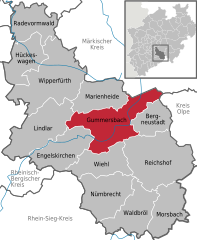
Location of Gummersbach within Oberbergischer Kreis district
  |
||
| Coordinates: 51°02′N 7°34′E / 51.033°N 7.567°ECoordinates: 51°02′N 7°34′E / 51.033°N 7.567°E | ||
| Country | Germany | |
| State | North Rhine-Westphalia | |
| Admin. region | Cologne | |
| District | Oberbergischer Kreis | |
| Government | ||
| • Mayor | Frank Helmenstein (CDU) | |
| Area | ||
| • Total | 95.3 km2 (36.8 sq mi) | |
| Elevation | 200-519 m (−1,503 ft) | |
| Population (2015-12-31) | ||
| • Total | 50,412 | |
| • Density | 530/km2 (1,400/sq mi) | |
| Time zone | CET/CEST (UTC+1/+2) | |
| Postal codes | 51643, 51645, 51647 | |
| Dialling codes | 02261, 02266 (Berghausen), 02354 (Lieberhausen), 02263 (Elbach) | |
| Vehicle registration | GM | |
| Website | www.gummersbach.de | |

Gummersbach is a town in the state of North Rhine-Westphalia, Germany, being the district seat of the Oberbergischer Kreis. It is located 50 km east of Cologne. The town is famous for its first league handball team VfL Gummersbach.
In 1109 Gummersbach was mentioned in official documents for the first time. The document in question concerned the lowering of the episcopal tax for the church in Gummersbach by Archbishop Frederick I. At that time the name of the town was spelled as Gumeresbracht. Gummersbach received town privileges in 1857. In 1855 Gummersbach's industrial history began with the foundation of the company Steinmüller. With the company's success the little village began to grow to a town. After going out of business most of the company's area was unused. Due to the fact that by the time this area made up half of the downtown area the town of Gummersbach bought this area to develop it. Today (2016) a multifunctional arena, a shopping mall, university buildings and offices have already been built.
The arms were granted on July 27, 1892. Gummersbach developed rapidly from a small village to a large town during the early 19th century, due to the metal and textile industry. The right part of the arms thus show a spindle as a symbol for the textile industry. The left part shows the arms of the Counts of the Mark, as the area belonged to the Mark since 1287.
Apfelbaum - Becke - Berghausen - Bernberg - Birnbaum - Börnchen - Bracht - Bredenbruch - Brink - Bruch - Brunohl - Berghausen - Deitenbach - Derschlag - Dieringhausen - Drieberhausen - Dümmlinghausen - Elbach - Erbland - Erlenhagen - Flaberg - Frömmersbach - Grünenthal - Gummeroth - Hardt - Hardt-Hanfgarten - Helberg - Herreshagen - Hesselbach - Höfen -Hömel - Hülsenbusch - Hunstig - Kalkuhl - Karlskamp - Koverstein - Lantenbach - Lieberhausen - Liefenroth - Lobscheid - Lützinghausen - Luttersiefen - Mühle - Neuenhaus - Neuenschmiede - Niedergelpe - Niedernhagen - Niederseßmar - Nochen - Oberrengse - Ohmig -Peisel - Piene - Rebbelroth - Recklinghausen - Reininghausen - Remmelsohl - Rodt - Rospe - Schneppsiefen - Schönenberg - Schusterburg - Sonnenberg - Steinenbrück - Straße - Strombach - Unnenberg - Veste - Vollmerhausen - Waldesruh - Wasserfuhr - Windhagen - Wörde - Würden
...
Wikipedia