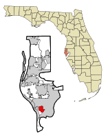
Gulfport, Florida
| Gulfport, Florida | |
|---|---|
| City | |
 Location in Pinellas County and the state of Florida |
|
| Coordinates: 27°45′2″N 82°42′31″W / 27.75056°N 82.70861°WCoordinates: 27°45′2″N 82°42′31″W / 27.75056°N 82.70861°W | |
| Country |
|
| State |
|
| County | Pinellas |
| Government | |
| • Mayor | Samuel Henderson |
| • Ward 1 | Daniel Liedtke |
| • Ward 2 | Christine Brown |
| • Vice Mayor | Yolanda Roman |
| • Ward 4 | Michael Fridovich |
| Area | |
| • Total | 3.8 sq mi (9.9 km2) |
| • Land | 2.8 sq mi (7.3 km2) |
| • Water | 1 sq mi (2.6 km2) |
| Elevation | 16 ft (5 m) |
| Population (2010) | |
| • Total | 12,029 |
| • Density | 3,200/sq mi (1,200/km2) |
| Time zone | Eastern (EST) (UTC-5) |
| • Summer (DST) | EDT (UTC-4) |
| ZIP codes | 33707, 33711, 33737 |
| Area code(s) | 727 |
| FIPS code | 12-28175 |
| GNIS feature ID | 0283501 |
| Website | www |
Gulfport is a city in Pinellas County,Florida, United States, bordering St. Petersburg and Boca Ciega Bay. The population of Gulfport was 12,029 at the 2010 census. Gulfport is part of the Tampa-St. Petersburg-Clearwater Metropolitan Statistical Area, the 19th largest MSA in the country.
The town was originally named Disston City in 1884 when Hamilton Disston purchased land in the area. The United States Postal Service would not recognize the name as it conflicted with a town in Hillsborough County. Instead, it was named Bonifacio. In 1890, the town name was changed to Veteran City. In 1910, the name officially changed to Gulfport.
"Old Florida" is a phrase often evoked in describing Gulfport's waterfront district, with its mix of small-scale cottages and small independent shops, restaurants and other businesses, situated among mature oak trees and brick-paved streets.
According to the United States Census Bureau, the city has a total area of 3.8 square miles (9.8 km2), of which 2.8 square miles (7.3 km2) is land and 1.0 square mile (2.6 km2) (26.30%) is water.
As of the census of 2000, there were 12,527 people, 6,246 households, and 3,154 families residing in the city. The population density was 4,422.2 inhabitants per square mile (1,709.1/km²). There were 7,306 housing units at an average density of 2,579.1 per square mile (996.8/km²). The racial makeup of the city was 89.40% White, 7.06% African American, 0.5% Asian, 0.4% Native American, 0.1% Pacific Islander, 0.78% from other races, and 1.75% from two or more races. Hispanic or Latino of any race were 3.47% of the population.
...
Wikipedia
