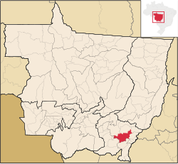
Guiratinga
| Guiratinga | ||
|---|---|---|
| Municipality | ||
| The Municipality of Guiratinga | ||
|
||
| Motto: Per Aspera Ad Astra - If Reaches For Rough Paths of Glory | ||
 Location of Guiratinga |
||
| Location of Guiratinga | ||
| Coordinates: 16°20′56″S 53°45′28″W / 16.34889°S 53.75778°WCoordinates: 16°20′56″S 53°45′28″W / 16.34889°S 53.75778°W | ||
| Country |
|
|
| Region | Central-West | |
| State |
|
|
| Mesoregion | (IBGE/2008 ) | |
| Microregion | (IBGE/2008 ) | |
| Founded | August 02, 1933 | |
| Founded by | Augusto Alves | |
| Vizinhos | Tesouro, Torixoréu, Araguainha, Alto Garças, Pedra Preta, São José do Povo, Poxoréo e Pontal do Araguaia | |
| Government | ||
| • Mayor | Hélio Goulart (DEM, since 2008) | |
| Area | ||
| • Total | 5,358.322 km2 (2,068.860 sq mi) | |
| Elevation | 510 m (1,670 ft) | |
| Population (IBGE 2012) | ||
| • Total | 14,137 | |
| • Density | 2.6/km2 (6.8/sq mi) | |
| Demonym(s) | Guiratinguense | |
| Time zone | UTC-4 (UTC-4) | |
| Zip Code | 78760-000 | |
| Area code(s) | 66 | |
| Climate | Tropical | |
| Distance from capital (Cuiabá) | 317 km | |
| Website | www |
|
Guiratinga (also known as Princess Eastern and initially as Lageado) is a city in the state of Mato Grosso, Brazil, distant about 320 miles from the capital Cuiabá. Like many cities in the region, its foundation is directly linked to mining activity that began in the 1920s.
It originates from the Tupi "Guira / gyra," which means, bird, bird or heron + "tinga", relating to the color white, white, clear, white heron.
The story must be told Guiratinga from the nineteenth century (1890) by sinalada raids Antônio Cândido de Carvalho, through Eastern Mato Grosso, pioneering and helping build several villages.
Then the Salesian Mission in Brazil, established to 06.18.1894, one of its dependencies in place called "Merure" in the center of the Bororo Indians, and this dependence was named "Colony Indigenous Sacred Heart of Jesus" under the direction of Father John Duroure of French origin.
Thanks to the persistent work of the Salesian Fathers and Daughters of Mary Help of Christians, who managed to pacify the Bororo was it possible to make the area habitable by white civilization.
In 1895, came to this northern region and Northeast, which had burrowing themselves in the forests and savannahs in search of rubber trees and the famous mangabeiras trees that proliferate across the entire Rio Araguaia and Herons and it was very rich in latex. With the shortage of rubber not many migrants returned to the region of origin, preferring to settle here.
By this time, came from Goiás and Minas families Moraes, Cajango and Balbino who settled in the region in order to explore the creation of cattle and subsistence farming.
João José de Moraes was Cajango with nickname "Cajango" miner, who was employed on the farm of his father Bravista realized that the gravel found there was very similar to their homeland, and this similarity began to investigate the possible existence of diamonds in the region. In one of these investigations, an Indian Bororo, said at the confluence of Cassununga Herons and there were lots of pebbles that glistened, which the Indians denominated in toricuiêgo.
Knowing the finding, Cajango used to tell these stories and other people who passed by.
In the year 1900, passes through the farm Boa Vista, a Bahian name Sezilo Feliciano dos Santos, who hears all aware of stories told by Cajango.
Feliciano, stimulated by it decides to fix the port indicated by the Bororo Indians, i.e., at the confluence of Cassununga and herons, that already by 1908, but Feliciano did not install yourself, brought a group of people among whom his wife, Jane Frances of Jesus.
One day, Jane Frances washing dishes in the river Cassununga feels a gravel different from others smote the dish, this small sample was taken to the farm Boa Vista and undertook to send Cajango analyze it and found to be diamond.
...
Wikipedia


