Guaratinguetá
| Guaratinguetá | |||
|---|---|---|---|
| Municipality | |||
 |
|||
|
|||
 Map showing the location of Guaratinguetá in São Paulo state |
|||
| Map showing the location of Guaratinguetá in São Paulo state | |||
| Coordinates: 22°49′00″S 45°13′40″W / 22.81667°S 45.22778°WCoordinates: 22°49′00″S 45°13′40″W / 22.81667°S 45.22778°W | |||
| Country |
|
||
| Region | Southeast Brazil | ||
| State | São Paulo | ||
| Metropolitan Region | Vale do Paraíba e Litoral Norte | ||
| Established | June 13, 1630 | ||
| Area | |||
| • Total | 752.64 km2 (290.60 sq mi) | ||
| Population (2015) | |||
| • Total | 119,073 | ||
| • Density | 160/km2 (410/sq mi) | ||
| Distance from state capital | São Paulo, 179 km (111 mi) | ||
| Website | www |
||
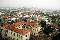
Guaratinguetá is a municipality in the state of São Paulo in Brazil. It is part of the Metropolitan Region of Vale do Paraíba e Litoral Norte. The population is 119,073 (2015 est.) in an area of 752.64 km². It is located in the region of Vale do Paraíba; prominent individuals from the area include Saint Frei Galvão, Brazilian President Rodrigues Alves and the cardiologist Dr Euryclides de Jesus Zerbini. The name of the city derives from the words in the Tupi language: gûyra (heron), tinga (white) and etá (), resulting in Gûyrating'etá (meeting of white herons).
The municipality contains part of the 292,000 hectares (720,000 acres) Mananciais do Rio Paraíba do Sul Environmental Protection Area, created in 1982 to protect the sources of the Paraíba do Sul river.
Since early times,Guaratinguetá was known by the Indians of the region for the abundance of herons that lived on the edges of the Paraíba do Sul river. The first Portuguese settlers arrived at the end of the 16th century, after rumours of mineral wealth hidden in Serra da Mantiqueira, in the lands known today as Minas Gerais. The settlement of the region began in 1628, with the donation of lands by Jacques Felix and his children. On June 13, 1630, construction began of a chapel, that was registered first in Livro-Tombo da Matriz of Santo Antonio.
On February 13, 1651, by intervention of Captain Domingos Leme, a village was raised for the Saint Antonio of Guaratinguetá, with the opening of the main road. By tradition, the pillory was also raised. During the 18th century, Guaratinguetá became the main point of supply for the gold miners coming from Minas Gerais as commerce on the route developed. During that period, the foreign travellers who had passed through there perpetuated the image of Guaratinguetá, as much in books as in paintings, and the village grew. The few narrow streets were filled by people at the end of the century on Sundays, holidays, and religious celebrations.
...
Wikipedia


