Guadalupe y Calvo Municipality
| Guadalupe y Calvo | |
|---|---|
| Municipality | |

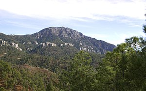
The Cerro Mohinora
|
|
 Municipality of Guadalupe y Calvo in Chihuahua |
|
| Location in Mexico | |
| Coordinates: 26°5′42″N 106°57′52″W / 26.09500°N 106.96444°WCoordinates: 26°5′42″N 106°57′52″W / 26.09500°N 106.96444°W | |
| Country |
|
| State | Chihuahua |
| Municipal seat | Guadalupe y Calvo |
| Area | |
| • Total | 9,165.1 km2 (3,538.7 sq mi) |
| Population (2010) | |
| • Total | 53,499 |
Guadalupe y Calvo is one of the 67 municipalities of Chihuahua, in northern Mexico. The municipal seat lies at Guadalupe y Calvo. The municipality covers an area of 9,165.1 km².
As of 2010, the municipality had a total population of 53,499, up from 51,854 as of 2005.
As of 2010, the town of Guadalupe y Calvo had a population of 5,816. Other than the town of Guadalupe y Calvo, the municipality had 1,416 localities, the largest of which (with 2010 populations in parentheses) were: Baborigame (3,294), classified as urban, and Atascaderos (1,559), Las Yerbitas (Aserradero) (1,200), and Turuachi (1,131), classified as rural.
The municipality has 1,086 localities. The largest are:
...
Wikipedia

