Groton (city), Connecticut
| City of Groton, Connecticut | |
|---|---|
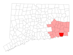
 Location of the Town of Groton within New London County, Connecticut |
|
| Coordinates: 41°20′45″N 72°01′47″W / 41.34583°N 72.02972°WCoordinates: 41°20′45″N 72°01′47″W / 41.34583°N 72.02972°W | |
| Country | United States |
| State | Connecticut |
| NECTA | Norwich-New London |
| Region | Southeastern Connecticut |
| Incorporated | 1964 |
| Government | |
| • Mayor | Dr. Marian K. Galbraith |
| • Deputy Mayor | Keith Hedrick |
| • City Councilors | Andrew Ilvento, Jill Rusk, Stephen Sheffield, Conrad Heede, Lawrence Gerrish |
| Area | |
| • Total | 6.8 sq mi (17.5 km2) |
| • Land | 3.1 sq mi (8.0 km2) |
| • Water | 3.7 sq mi (9.5 km2) |
| Population (2010) | |
| • Total | 9,395 |
| • Density | 1,400/sq mi (540/km2) |
| Time zone | Eastern (UTC-5) |
| • Summer (DST) | Eastern (UTC-4) |
| ZIP code | 06340 |
| Website | www |
The City of Groton is a dependent political subdivision of the Town of Groton in New London County, Connecticut, United States. The population was 9,395 at the 2010 census. The city is located in the western edge of the town, west of Plain Creek and south of Grove Avenue.
First settled in 1655 as Groton Bank, the area occupied by the present city of Groton developed into the principal village of the town of Groton. The village of Groton incorporated as a borough in 1903. In 1964, the residents of the borough of Groton reincorporated as the city of Groton. It is the only remaining city in the state of Connecticut that is not governmentally and areally consolidated with its parent town.
According to the United States Census Bureau, the city has a total area of 6.8 square miles (17.5 km2), of which 3.1 square miles (8.0 km2) is land and 3.7 square miles (9.5 km2), or 54.39%, is water.
As of the census of 2000, there were 10,010 people, 4,230 households, and 2,444 families residing in the city. The population density was 3,138.0 people per square mile (1,211.6/km²). There were 4,569 housing units at an average density of 1,432.3 per square mile (553.0/km²). The racial makeup of the city was 77.72% White, 10.18% Black or African American, 0.93% Native American, 3.55% Asian, 0.05% Pacific Islander, 2.84% from other races, and 4.74% from two or more races. Hispanic or Latino of any race were 7.72% of the population.
...
Wikipedia
