
Großräschen
| Großräschen | ||
|---|---|---|
 |
||
|
||

Großräschen
|
||
|
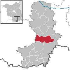
Location of Großräschen within Oberspreewald-Lausitz district
  |
||
| Coordinates: 51°34′59″N 14°00′00″E / 51.58306°N 14.00000°ECoordinates: 51°34′59″N 14°00′00″E / 51.58306°N 14.00000°E | ||
| Country | Germany | |
| State | Brandenburg | |
| District | Oberspreewald-Lausitz | |
| Government | ||
| • Mayor | Thomas Zenker (SPD) | |
| Area | ||
| • Total | 81.29 km2 (31.39 sq mi) | |
| Elevation | 115 m (377 ft) | |
| Population (2015-12-31) | ||
| • Total | 8,655 | |
| • Density | 110/km2 (280/sq mi) | |
| Time zone | CET/CEST (UTC+1/+2) | |
| Postal codes | 01983 | |
| Dialling codes | 035753 | |
| Vehicle registration | OSL | |
| Website | www.grossraeschen.de | |

Großräschen (Sorbian: Rań) is a town in Lower Lusatia, in Germany. Administratively, it is part of the district of Oberspreewald-Lausitz, in the state of Brandenburg.
Großräschen is situated south of the Niederlausitzer Landrücken, a sandy stretch of land grown with pine forests in the centre of Lusatia. The small river Rainitza used to take its source in meadows north of the town centre. South of the town, Lake Ilse (now an open-cast lignite mine) will be completed around 2020. The town proper comprises the historical core, Kleinräschen, as well as Großräschen. The southernmost quarter, Bückgen, was pulled down due to mining. Outside the town proper, the villages of Freienhufen (historically Dobristroh) with Bulldorf, Dörrwalde, Wormlage, Saalhausen, Woschkow, and Schmogro (Großräschen-Ost).
Both Großräschen and Kleinräschen were first mentioned in an official document in 1370. Form of settlement and the name suggest that Kleinräschen is older than Großräschen. The villages developed slowly; the Wendish population depended almost entirely on agriculture. From the middle of the 19th century onwards, heavy industry developed, and the villages grew rapidly. In 1965, they were granted the status of a town, having been incorporated into one community in 1925. The 1980s brought the destruction of Bückgen, whose inhabitants (4000 of them had to leave their homes) were moved into blocks of flats. After the fall of the Berlin Wall, the decline of the industries (glass manufacturing, brick production, mining and agriculture used to be presented in the town's coat of arms) caused heavy unemployment.
Thomas Zenker (SPD) was elected in November 2009 with 93,9 % of the votes for a term of eight years. (Poll 35,3 %).
Development of Population since 1875 within the Current Boundaries (Blue Line: Population; Dotted Line: Comparison to Population Development of Brandenburg state; Grey Background: Time of Nazi rule; Red Background: Time of Communist rule)
Recent Population Development (Blue Line) and Forecasts
Kurmärker Großräschen, mit Wettigs Hof (13.03.2007)
IBA-Geschäftsstelle Großräschen (13.03.2007)
...
Wikipedia