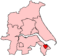
Grimsby, Lincolnshire
| Great Grimsby | |
|---|---|
 Grimsby Dock Tower |
|
 Coat of arms of Grimsby |
|
| Great Grimsby shown within Lincolnshire | |
| Population | 88,243 (2011) |
| OS grid reference | TA279087 |
| • London | 140 mi (230 km) S |
| Unitary authority | |
| Ceremonial county | |
| Region | |
| Country | England |
| Sovereign state | United Kingdom |
| Post town | GRIMSBY |
| Postcode district | DN31 – DN34, DN35, DN37 |
| Dialling code | 01472 |
| Police | Humberside |
| Fire | Humberside |
| Ambulance | East Midlands |
| EU Parliament | Yorkshire and the Humber |
| UK Parliament | |
| Great Grimsby | |
|---|---|
 Grimsby town hall |
|
 Great Grimsby as a Borough of Humberside |
|
| Area | |
| • 1911 | 2,868 acres (11.61 km2) |
| • 1961 | 5,881 acres (23.80 km2) |
| History | |
| • Created | 1835 |
| • Abolished | 1996 |
| • Succeeded by | North East Lincolnshire |
| Status |
Town Charter Granted 1201 Municipal Borough (1835–1889) County Borough (1889–1974) Borough (1974–1996) |
| • HQ | Grimsby |
 Arms of Great Grimsby Borough Council |
|
Grimsby, also known as Great Grimsby, is a large town and seaport in Lincolnshire, England, on the South Bank of the Humber Estuary close to where it reaches the North Sea. It is the administrative centre of North East Lincolnshire.
Grimsby developed as a major sea port on the east coast of England, hosting the largest fishing fleet in the world by the mid-20th century. The fishing industry declined dramatically after the Cod Wars. Since then the town has battled with post-industrial decline. Since the 1990s the local council has encouraged food manufacturing.
The Grimsby–Cleethorpes conurbation acts as the cultural, shopping and industrial centre for a large area of northern and eastern Lincolnshire.
People from Grimsby are called Grimbarians; the term (plural codheads) is also used jokingly or disparagingly, often with reference to Grimsby football supporters. 22 January is Great Grimsby Day.
The town was titled "Great Grimsby" to distinguish it from Little Grimsby, a village about 14 miles (22 km) to the south, near Louth.
The town had a population of 88,243 in 2011. It is physically linked to and forms a conurbation with the adjoining town of Cleethorpes. Some 11,000 of its residents live in the village of Scartho, which was absorbed into Grimsby before 20th-century laws on the green belt were passed. All three areas come under the jurisdiction of the same unitary authority, North East Lincolnshire. It is close to the main terminus of the A180, which ends in Cleethorpes.
Grimsby lies in the national character areas of the Humber, and the Lincolnshire coast and Marshes; it is predominantly low in topography. The town was historically settled on low-lying islands and raised areas of the Humber marsh, and subsequently expanded onto the surrounding marshes as they were drained. The town still has areas named East Marsh and West Marsh. The Lincolnshire Wolds are situated to the south west of the town, from which the town's River Freshney rises.
...
Wikipedia

