Lincolnshire Wolds
| Lincolnshire Wolds | |
| Area of Outstanding Natural Beauty | |
|
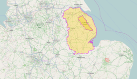
The Lincolnshire Wolds (top), location within Lincolnshire (bottom)
|
|
| Country | England |
|---|---|
| County | Lincolnshire |
| Location | Midlands |
| - coordinates | 53°21′0″N 0°6′0″W / 53.35000°N 0.10000°WCoordinates: 53°21′0″N 0°6′0″W / 53.35000°N 0.10000°W |
| Highest point | |
| - location | Wolds Top |
| - elevation | 168 m (551 ft) |
| Area | 560 km2 (216 sq mi) |
| Geology | chalk, clay, limestone, sandstone |
| Plants | hawthorn, gentian, kidney vetch |
| Animals | Kestrel, meadow pipit, short-eared owl, woodcock |
| Founded | 1973 |
| Management | Lincolnshire Wolds Countryside Service |
|
Location of the Lincolnshire Wolds AONB in the UK
|
|
The Lincolnshire Wolds is a range of hills in the county of Lincolnshire, England. It is a designated Area of Outstanding Natural Beauty (AONB), and the highest area of land in eastern England between Yorkshire and Kent. They run roughly parallel with the North Sea coast, from the River Humber in the north-west to the edge of the Lincolnshire Fens in the south-east.
The Wolds comprise a series of low hills and steep valleys underlain by calcareous (chalk and limestone) and sandstone rock, laid down in the Cretaceous period. The characteristic open valleys of the Wolds were created during the last glacial period through the action of glaciation and meltwater.
Geologically, the Lincolnshire Wolds is a continuation of the Yorkshire Wolds which runs through the East Riding of Yorkshire; the point at which the ranges of hill crosses the Humber is known as the Humber Gap.
The Lincolnshire Wolds can be divided into four distinct areas:
The Red Hill nature reserve near the village of Goulceby is notable for the unusual red colour of its soil and underlying chalk.
Wolds Top is the highest point in the whole of Lincolnshire and is marked by a trig point just north of the village of Normanby le Wold, at approximately 551 feet (168 metres) above sea level (TF121964).
...
Wikipedia


