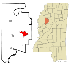
Greenwood, Mississippi
| Greenwood, Mississippi | |
|---|---|
| City | |
 |
|
| Nickname(s): Cotton Capital of the World | |
 Location of Greenwood, Mississippi |
|
| Location in the United States | |
| Coordinates: 33°31′7″N 90°11′2″W / 33.51861°N 90.18389°WCoordinates: 33°31′7″N 90°11′2″W / 33.51861°N 90.18389°W | |
| Country | United States |
| State | Mississippi |
| County | Leflore |
| Area | |
| • Total | 13 sq mi (33.7 km2) |
| • Land | 12.4 sq mi (32.1 km2) |
| • Water | 0.6 sq mi (1.6 km2) |
| Elevation | 131 ft (40 m) |
| Population (2010) | |
| • Total | 16,087 |
| Time zone | Central (CST) (UTC-6) |
| • Summer (DST) | CDT (UTC-5) |
| ZIP codes | 38930, 38935 |
| Area code(s) | 662 |
| FIPS code | 28-29340 |
| GNIS feature ID | 0670714 |
| Website | www |
Greenwood is a city in and the county seat of Leflore County, Mississippi, located at the eastern edge of the Mississippi Delta, approximately 96 miles north of Jackson, Mississippi, and 130 miles south of Memphis, Tennessee. It was a center of cotton planter culture in the 19th century.
The population was 16,087 at the 2010 census. It is the principal city of the Greenwood Micropolitan Statistical Area. The Tallahatchie and the Yalobusha rivers meet at Greenwood to form the Yazoo River. Throughout the 1960s, Greenwood was the site of major protests and conflicts as African Americans worked to achieve racial integration and voting access during the civil rights movement.
The flood plain of the Mississippi River has long been an area rich in vegetation and wildlife, fed by the Mississippi and its numerous tributaries. Long before Europeans migrated to America, the Choctaw and Chickasaw Indian nations settled in the Delta's bottomlands and throughout what is now central Mississippi. They were descended from indigenous peoples who had lived in the area for thousands of years, including the Mississippian culture, which built earthwork mounds beginning about 950CE.
In the nineteenth century, the Five Civilized Tribes in the Southeast suffered increasing encroachment on their territory by European-American settlers from the United States. Under pressure from the United States government, in 1830 the Choctaw principal chief Greenwood LeFlore and other Choctaw leaders signed the Treaty of Dancing Rabbit Creek, ceding most of their remaining land to the United States in exchange for land in Indian Territory, what is now southeastern Oklahoma. The government opened the land for sale and settlement by European Americans. LeFlore came to regret his decision to sign away his people's land, saying in 1843 that he was "sorry to say that the benefits realized from [the treaty] by my people were by no means equal to what I had a right to expect, nor to what they were justly entitled."
...
Wikipedia

