Greensboro, Georgia
| Greensboro, Georgia | |
|---|---|
| City | |

Greene County Courthouse in Greensboro
|
|
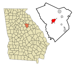
 Location in Greene County and the state of Georgia |
|
| Coordinates: 33°34′18″N 83°10′51″W / 33.57167°N 83.18083°WCoordinates: 33°34′18″N 83°10′51″W / 33.57167°N 83.18083°W | |
| Country | United States |
| State | Georgia |
| County | Greene |
| Area | |
| • Total | 6.8 sq mi (17.6 km2) |
| • Land | 6.7 sq mi (17.4 km2) |
| • Water | 0.08 sq mi (0.2 km2) |
| Elevation | 640 ft (195 m) |
| Population (2010) | |
| • Total | 3,359 |
| • Density | 499/sq mi (192.8/km2) |
| Time zone | Eastern (EST) (UTC-5) |
| • Summer (DST) | EDT (UTC-4) |
| ZIP code | 30642 |
| Area code(s) | Area code 706 |
| FIPS code | 13-34876 |
| GNIS feature ID | 0356104 |
| Website | www |
The city of Greensboro is the county seat of Greene County, Georgia, United States. Its population was 3,359 as of the 2010 census.
Greensboro was founded around 1780. In 1787, it was designated seat of the newly formed Greene County. It was incorporated as a town in 1803 and as a city in 1855.
Greensboro is located at the center of Greene County at 33°34′18″N 83°10′51″W / 33.57167°N 83.18083°W (33.571528, -83.180921).U.S. Route 278 passes through the city center as Broad Street, leading east 7 miles (11 km) to Union Point and west 19 miles (31 km) to Madison. Georgia State Route 44 leads southwest from Greensboro 22 miles (35 km) to Eatonton. State Route 15 leads north 34 miles (55 km) to Athens and southeast 27 miles (43 km) to Sparta. The city limits extend southwest along SR 44 for 4 miles (6 km) so as to include Exit 130 on Interstate 20. I-20 leads east 70 miles (110 km) to Augusta and west 73 miles (117 km) to Atlanta.
According to the U.S. Census Bureau, Greensboro has a total area of 6.8 square miles (17.6 km2), of which 6.7 square miles (17.4 km2) is land and 0.1 square miles (0.2 km2), or 0.99%, is water. The city is in the Oconee River watershed and is located 5 miles (8 km) east of Lake Oconee and 2 miles (3 km) southeast of Oconee National Forest.
...
Wikipedia
