Eatonton, Georgia
| Eatonton, Georgia | |
|---|---|
| City | |

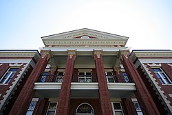
Putnam County Courthouse in Eatonton
|
|
 Location in Putnam County and the state of Georgia |
|
| Coordinates: 33°19′35″N 83°23′16″W / 33.32639°N 83.38778°WCoordinates: 33°19′35″N 83°23′16″W / 33.32639°N 83.38778°W | |
| Country | United States |
| State | Georgia |
| County | Putnam |
| Area | |
| • Total | 20.7 sq mi (53.5 km2) |
| • Land | 20.6 sq mi (53.2 km2) |
| • Water | 0.1 sq mi (0.3 km2) |
| Elevation | 568 ft (173 m) |
| Population (2010) | |
| • Total | 6,764 |
| • Density | 326.8/sq mi (126.4/km2) |
| Time zone | Eastern (EST) (UTC-5) |
| • Summer (DST) | EDT (UTC-4) |
| ZIP codes | 31024 |
| Area code(s) | 706 |
| FIPS code | 13-26084 |
| GNIS feature ID | 0331628 |
| Website | City of Eatonton |
Eatonton is a city in and county seat of Putnam County, Georgia, United States. As of the 2010 census, the city had a population of 6,480. It was named after William Eaton, an officer and diplomat involved in the First Barbary War. The name consists of his surname with the English suffix "ton," meaning "town."
The Rock Eagle Effigy Mound, a Native American archaeological site, is located north of the city. It is one of two such sites east of the Mississippi River; both are in Putnam County. The mound and related earthwork constructions were made by Woodland culture peoples, perhaps as long ago as 1,000 to 3,000 years. The site within a 1500-acre park administered by the University of Georgia, which also maintains a 4-H camp nearby. The Mound has been listed on the National Register of Historic Places.
Following the American Revolutionary War, Eatonton was founded in 1807 as the seat of newly formed Putnam County. After the war, settlers were moving west and settling in the upland Piedmont region to develop cotton plantations. Eatonton was incorporated as a town in 1809 and as a city in 1879.
In the 21st century, Eatonton is known as the "Dairy Capital of Georgia" (in honor of its major industry, dairy farming).
Eatonton is located at 33°19′35″N 83°23′16″W / 33.32639°N 83.38778°W (33.326302, -83.387798).
...
Wikipedia
