Greenisland
Greenisland
|
|
|---|---|
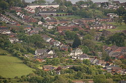
 Greenisland, as viewed from the Knockagh Monument |
|
| Greenisland shown within Northern Ireland | |
| Population | 5,050 (2001 Census) |
| District | |
| County | |
| Country | Northern Ireland |
| Sovereign state | United Kingdom |
| Post town | CARRICKFERGUS |
| Postcode district | BT38 |
| Dialling code | 028 |
| EU Parliament | Northern Ireland |
| UK Parliament | |
Greenisland is a village in County Antrim, Northern Ireland. It lies 7 miles north-east of Belfast and 3 miles south-west of Carrickfergus. The village is on the coast of Belfast Lough and is named after a tiny islet to the west, the Green Island.
It is a semi-rural community located at the foot of Carn Hill , upon which stands the Knockagh Monument, a war memorial for those from County Antrim who died in the first and second world wars.
The village has two distinct areas, known locally as Upper Greenisland and Lower Greenisland after the upper Station Road and lower Station Road around which two parts are respectively located. Upper Greenisland stretches from Upper Road (B90) to the railway station at the bottom of Upper Station Road, includes Greenisland Primary School and features predominantly middle-class demographics and housing. Lower Greenisland runs from the railway station, down Station Road and ends at Shore Road (part of the A2 road). It features a large, predominantly working-class housing estate built during the 1950s and 1960s and includes Greenisland Library, Greenisland Community Centre, a number of churches, a small shopping parade at Glassillan Court and Silverstream Primary School. The village in its entirety stretches from the foot of the hill to the shore of Belfast Lough.
Originally, the area now known as Greenisland was merely an unnamed area of the town of Carrickfergus with the Silverstream river, now the western boundary of Greenisland, marking the westernmost boundary of the large town. Today, roadsigns indicate that the river, which now flows through the grounds of Belfast High School, is the exact boundary between the Carrickfergus and Newtownabbey boroughs. From 1602 to 1606 the "freemen", leading citizens of Carrickfergus, obtained the right to redistribute this area of land from the Crown, renaming the area the West Division - a name which remains legal today.
...
Wikipedia

