Green Harbor-Cedar Crest, Massachusetts
| Green Harbor, Massachusetts | |
|---|---|
| Census-designated place | |

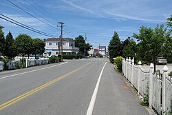
Bay Avenue
|
|
| Nickname(s): Green Harbor | |
| Motto: I Love Green Habah | |
| Coordinates: 42°4′25″N 70°39′22″W / 42.07361°N 70.65611°WCoordinates: 42°4′25″N 70°39′22″W / 42.07361°N 70.65611°W | |
| Country | United States |
| State | Massachusetts |
| County | Plymouth |
| Area | |
| • Total | 1.9 sq mi (5.0 km2) |
| • Land | 1.8 sq mi (4.6 km2) |
| • Water | 0.2 sq mi (0.4 km2) |
| Population (2010) | |
| • Total | 2,609 |
| • Density | 1,400/sq mi (520/km2) |
| Time zone | Eastern (EST) (UTC-5) |
| • Summer (DST) | EDT (UTC-4) |
| Area code(s) | 339 / 781 |
| FIPS code | 25-27147 |
Green Harbor-Cedar Crest is a census-designated place (CDP) in the towns of Duxbury, Massachusetts and Marshfield, Massachusetts in Plymouth County, United States. It includes the village of Green Harbor. Cedar Crest is the name of a hill located on the north side of Careswell St. The population was 2,609 at the 2010 census.
Green Harbor was originally known as "Green's Harbor." The name derives from William Green. The Pilgrim government granted William Green rights to conduct commercial fishing there in about 1627. The original name for Cedar Crest was Gotham Hill. In the 1920s 3 seasonal children's camps were created on the west end of the hill. The Immaculate Conception Boys Brigade, under the direction of Monsignor Edward M. Hartigan from the Immaculate Conception Church in Everett, MA, bought out the other 2 camps and created 1 camp. At the time the hill did not have any trees since it had been farmland for a number of years. There was a growth of small cedar trees on the top of the hill. This inspired Monsignor Hartigan to name the combined camps "Cedar Crest" and the name was emblazoned on the side of the hill in white painted stones. Ever since, the entire hill has been called Cedar Crest.
Green Harbor-Cedar Crest is located at 42°4′25″N 70°39′22″W / 42.07361°N 70.65611°W (42.073624, -70.656161).
According to the United States Census Bureau, the CDP has a total area of 5.0 km² (1.9 mi²), of which 4.6 km² (1.8 mi²) is land and 0.4 km² (0.2 mi²) (8.29%) is water.
...
Wikipedia
