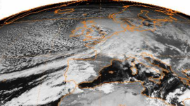
Great Storm of 1990

Burns' Day Storm/Daria 11:30UTC 25 January 1990
|
|
| Type | European windstorm, extratropical, extratropical storm surge |
|---|---|
| Formed | 23 January 1990 |
| Dissipated | 26 January 1990 |
| Lowest pressure | 949 hPa (28.0 inHg) |
| Highest winds |
|
| Highest gust | 93 kn (172 km/h; 107 mph), Aberporth, Wales and Gwennap Head, Cornwall |
| Total fatalities | 97 (Met Office) |
| Areas affected | Ireland, United Kingdom, France, Belgium, Netherlands, West Germany, East Germany, Denmark |
The Burns' Day Storm took place on 25–26 January 1990 over north-western Europe and is one of the strongest European windstorms on record. This storm has received different names as there is no official list of such events in Europe. It is also known as Daria. Starting on the birthday of Scottish poet Robert Burns, it caused widespread damage and hurricane-force winds over a wide area. The storm was responsible for 97 deaths (according to the Met Office), although figures have ranged from 89 to over 100.
The storm began as a cold front over the Northern Atlantic Ocean on 23 January. By the 24th, it had a minimum central pressure of 992 mbar. It made landfall on the morning of the 25th over Ireland, where 17 died, including 8 on a bus which was struck by a falling tree. It then tracked over to Ayrshire in Scotland. The lowest pressure of 949 mbar was recorded near Edinburgh around 16:00. After hitting the United Kingdom, the storm tracked rapidly east towards Denmark, causing major damage and 30 deaths in the Netherlands and Belgium.
The strongest sustained winds recorded were between 70 and 75 mph (110–120 km/h), comparable to a weak Category 1 hurricane or Hurricane-force 12 on the Beaufort Scale. Strong gusts of up to 104 mph (170 km/h;) were reported, and it was these which caused the most extensive damage.
The Burns' Day Storm of 1990 has been given as an example of when the Met Office "got the prediction right". The model forecast hinged on observations from two ships in the Atlantic near the developing storm the day before it reached the UK.
During the day of the storm the Royal Netherlands Meteorological Institute (KNMI) increased warnings to force 11 and eventually to hurricane force 12. Research conducted by them showed that most of the general public were not able to understand the severity of the warnings. The storm has led to more awareness about the understanding of storminess among the public by the KNMI, who started a teletext page and the introduction of special warnings for extreme weather events in reaction to these findings.
...
Wikipedia
