Great Seto Bridge
| Great Seto Bridge (瀬戸大橋 Seto Ōhashi?) |
|
|---|---|

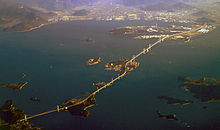
Great Seto Bridge from Honshū (left) via the islands of Hitsuishijima and Yoshima to Shikoku
|
|
| Coordinates | Coordinates: 34°23′54″N 133°48′36″E / 34.39833°N 133.81000°E |
| Carries | 4 lanes of roadway (upper) 2 rail lines (lower) |
| Crosses | Seto Inland Sea |
| Locale | Honshū and Shikoku |
| Maintained by | Honshu–Shikoku Bridge Authority |
| Characteristics | |
| Design | Double-decked bridge system |
| Total length | 13.1 km (8.1 mi) |
| History | |
| Opened | 1988 |
| Statistics | |
| Toll | 4,850 yen |
The Great Seto Bridge (瀬戸大橋 Seto Ōhashi?) is a series of double deck bridges connecting Okayama and Kagawa prefectures in Japan across a series of five small islands in the Seto Inland Sea. Built over the period 1978–88, it is one of the three routes of the Honshū–Shikoku Bridge Project connecting Honshū and Shikoku islands, and the only one with railroad connections included. At 13.1 kilometers (8.1 mi), it ranks as the world's longest two-tiered bridge system.
Crossing the bridge takes about 20 minutes by car or train. The ferry crossing before the bridge was built took about an hour. The non-discounted toll from Kojima, Kurashiki (Okayama Prefecture on the Honshu side) to Sakaide (Kagawa Prefecture on the Shikoku side) is ¥3,500, and vice versa.
The bridges carry two lanes of highway traffic in each direction (Seto-Chūō Expressway) on the upper deck and one railway track in each direction (Seto-Ōhashi Line) on the lower deck. The lower deck was designed to accommodate an additional Shinkansen rail line in each direction.
When in 1889 the first railway in Shikoku - between Marugame and Kotohira - was completed, a member of the Prefectural Parliament, Jinnojo Ōkubo (大久保諶之丞 Ōkubo Jinnojo?, 1849–1891), stated in his speech at the opening ceremony: "The four provinces of Shikoku are like so many remote islands. If united by roads, they will be much better off, enjoying the benefits of increased transportation and easier communication with each other."
...
Wikipedia
