Great Falls Park
| Great Falls Park | |
|---|---|
|
IUCN category V (protected landscape/seascape)
|
|
 |
|
| Location | Fairfax County, Virginia, USA |
| Nearest city | McLean, Virginia |
| Coordinates | 38°59′39″N 77°15′09″W / 38.994239°N 77.252426°WCoordinates: 38°59′39″N 77°15′09″W / 38.994239°N 77.252426°W |
| Area | 800 acres (320 ha) |
| Established | 1966 |
| Visitors | 645,000 (in 2002) |
| Governing body | National Park Service |
| Great Falls (climbing area) | |
|---|---|
 |
|
| Location | Fairfax County, Virginia, USA |
| Nearest city | McLean, Virginia |
| Coordinates | 38°59′20.87″N 77°14′51.52″W / 38.9891306°N 77.2476444°W |
| Climbing type | top-rope crag |
| Height | 35-50 feet |
| Pitches | 1 |
| Ratings | 5.0-5.12 |
| Grades | I |
| Rock type | Wissahikon Mica-schist with quartz crystals |
| Quantity of rock | days worth |
| Development | very well developed |
| Cliff aspect | East facing |
| Season | spring to fall |
| Ownership | National Park Service |
| Camping | none |
| Classic climbs |
|
| Stars | |
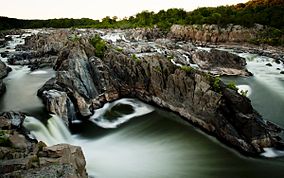
Great Falls Park is a small National Park Service (NPS) site in Virginia, United States. Situated on 800 acres (3.65 km2) along the banks of the Potomac River in northern Fairfax County, the park is a disconnected but integral part of the George Washington Memorial Parkway. The Great Falls of the Potomac River are near the northern boundary of the park, as are the remains of the Patowmack Canal, the first canal in the United States that used locks to raise and lower boats.
Native American petroglyphs have been discovered within the park on cliffs overlooking Difficult Run.
The Patowmack Canal, which George Washington partially funded, was a one-mile (1.6 km) bypass canal that began operating in 1785 to give small barges the opportunity to skirt around the falls and to distribute manufactured goods upstream and raw materials downstream. The park visitor center has the bottom portions of two wooden canal lock gates excavated in the 1980s from the canal. The gates survived from at least the 1830s and were found during restoration projects on stonework which were erected for the canal locks. Stonemason marks found on the stones are unique to each artisan and are identical to some found in foundation stones of the White House and the U.S. Capitol.
During the construction of the canal, blasting powder, which at the time was essentially gunpowder, was used to blast through solid rocks. This is one of the first known examples of blasting powder being used for engineering purposes anywhere in the world. The canal was never a profitable enterprise. With the completion of the Chesapeake and Ohio Canal on the opposite side of the river, and the oncoming age of railroads, the project was abandoned in 1830. The canal is a Civil Engineering Landmark as well as a Virginia Historic Landmark. Along the trails, the ruins of the small town of Matildaville, Virginia can also be found.
...
Wikipedia


