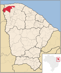
Granja, Ceará
| Granja | |||
|---|---|---|---|
|
|||
 Location of Granja in Ceará |
|||
| Coordinates: 03°07′12″S 40°49′33″W / 3.12000°S 40.82583°WCoordinates: 03°07′12″S 40°49′33″W / 3.12000°S 40.82583°W | |||
| Country | Brazil | ||
| Region | Northeast | ||
| State | Ceará | ||
| Founded | 1776 | ||
| Government | |||
| • Mayor | Francisco Geovane da Rocha Brito | ||
| Area | |||
| • Total | 2,697.202 km2 (1,041.396 sq mi) | ||
| Elevation | 10 m (30 ft) | ||
| Population (2008) | |||
| • Total | 53,486 | ||
| • Density | 19.9/km2 (52/sq mi) | ||
| Time zone | AST (UTC-3) | ||
| HDI (2000) | 0.554 – medium | ||
Granja is the westernmost municipality in the Brazilian state of Ceará.
The municipality contains part of the 1,592,550 hectares (3,935,300 acres) Serra da Ibiapaba Environmental Protection Area, created in 1996.
...
Wikipedia


