Granite Falls, Minnesota
| Granite Falls | |
|---|---|
| City | |
| Granite Falls, Minnesota | |

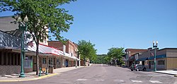
Prentice Street in downtown Granite Falls in 2007
|
|
 Location of Granite Falls within Yellow Medicine County, Minnesota |
|
| Coordinates: 44°48′38″N 95°32′36″W / 44.81056°N 95.54333°W | |
| Country | United States |
| State | Minnesota |
| Counties | Chippewa, Renville, Yellow Medicine |
| Area | |
| • Total | 3.82 sq mi (9.89 km2) |
| • Land | 3.59 sq mi (9.30 km2) |
| • Water | 0.23 sq mi (0.60 km2) |
| Elevation | 919 ft (280 m) |
| Population (2010) | |
| • Total | 2,897 |
| • Estimate (2013) | 2,806 |
| • Density | 807.0/sq mi (311.6/km2) |
| Time zone | Central (CST) (UTC-6) |
| • Summer (DST) | CDT (UTC-5) |
| ZIP code | 56241 |
| Area code(s) | 320 |
| FIPS code | 27-25280 |
| GNIS feature ID | 0644347 |
| Website | City of Granite Falls |
Granite Falls is a city in Chippewa, Renville and Yellow Medicine counties in the State of Minnesota. The population was 2,897 at the 2010 census. It is the county seat of Yellow Medicine County. The Andrew John Volstead House, a National Historic Landmark, is located in Granite Falls.
Granite Falls was platted in 1872. The city was named for deposits of granite rock in the area. A post office has been in operation at Granite Falls since 1870. Granite Falls was incorporated as a city in 1889.
On July 25, 2000, the city of Granite Falls and Yellow Medicine County were hit by a powerful tornado. The tornado first touched down in rural parts of the county west-northwest of Granite Falls, hitting the city at 6:10 pm. After tearing through the residential sections of town, the tornado lifted at approximately 6:25PM after being on the ground for over nine miles. One person was killed, more than a dozen were injured, and the town and surrounding area suffered millions of dollars in property damage.
While the damage in Granite Falls was generally limited to that of F-2 and F-3 storms, the extent of the damage at the corner of 9th Avenue and 14th Street caused the National Weather Service to classify it as an F-4 storm.
According to the United States Census Bureau, the city has a total area of 3.82 square miles (9.89 km2); 3.59 square miles (9.30 km2) is land and 0.23 square miles (0.60 km2) is water.
U.S. Highway 212 and Minnesota State Highways 23 and 67 are three of the main routes in the city.
...
Wikipedia
