Grand Terrace, California
| City of Grand Terrace | ||
|---|---|---|
| City | ||

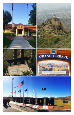
City of Grand Terrace images from top, left to right - Grand Terrace City Hall, Blue Mountain Trail, Northeast City Entrance, Historical Plaque, Veterans Wall of Freedom
|
||
|
||
 Location in San Bernardino County and the state of California |
||
| Location in the United States | ||
| Coordinates: 34°02′02″N 117°18′49″W / 34.03389°N 117.31361°WCoordinates: 34°02′02″N 117°18′49″W / 34.03389°N 117.31361°W | ||
| Country |
|
|
| State |
|
|
| County | San Bernardino | |
| Incorporated | November 30, 1978 | |
| Government | ||
| • Type | Council-manager | |
| • Mayor | Darcy McNaboe | |
| • City Manager | G. Harold Duffey | |
| Area | ||
| • Total | 3.502 sq mi (9.070 km2) | |
| • Land | 3.502 sq mi (9.070 km2) | |
| • Water | 0 sq mi (0 km2) 0% | |
| Elevation | 1,063 ft (324 m) | |
| Population (April 1, 2010) | ||
| • Total | 12,040 | |
| • Estimate (2013) | 12,337 | |
| • Density | 3,400/sq mi (1,300/km2) | |
| Time zone | PST (UTC-8) | |
| • Summer (DST) | PDT (UTC-7) | |
| ZIP code | 92313 | |
| Area code(s) | 909 | |
| FIPS code | 06-30658 | |
| GNIS feature ID | 1660692 | |
| Website | www |
|
Grand Terrace is a city in San Bernardino County, California, United States. The population was 12,040 at the 2010 census, up from 11,626 at the 2000 census. Grand Terrace is located between Highgrove and Colton, along the 215 and Aqua Mansa industrial corridors. The city is situated between two mountain ridges: Blue Mountain to the east and the La Loma Hills to the west.
Grand Terrace's roots go back to Mexican land grants dating from the period between 1830 and 1840. Mormon settlers came shortly after, arriving in the San Bernardino Valley, during the 1850s. According to the Riverside Press, in 1876, there were nine buildings in the Terrace-Colton area. Originally, the area was simply referred to as "the Terrace," but the word "Grand," was added around 1898 due to the beautiful views which surround the city. In 1905, Seventh-day Adventists, whose medical university is now located in nearby Loma Linda, settled in the area. Grand Terrace experienced continued growth and development during the Southern California suburbia and sunbelt periods in the late half of the 20th century.
The development of Grand Terrace, or East Riverside, as the Grand Terrace-Highgrove area was called, became a reality with the construction of the Gage Canal. This 22-1/2 mile canal, built at a cost of 2 million dollars, brought water from the Santa Ana River marshlands below The Terrace. With plenty of irrigation water, Grand Terrace rapidly became an agricultural community featuring fine, quality citrus. However, the severe "freeze" of 1913 destroyed many groves. Walnuts, a hardier tree, were planted as replacements along with peaches as a quick-profit crop.
...
Wikipedia


