Grand Atlas
| High Atlas | |
|---|---|

Jbel Toubkal in Toubkal National Park
|
|
| Highest point | |
| Peak | Jbel Toubkal |
| Elevation | 4,167 m (13,671 ft) |
| Coordinates | 31°03′43″N 7°54′58″W / 31.06194°N 7.91611°W |
| Geography | |
| Country | Morocco |
| Range coordinates | 31°26′N 6°56′W / 31.433°N 6.933°WCoordinates: 31°26′N 6°56′W / 31.433°N 6.933°W |
| Parent range | Atlas Mountain System |
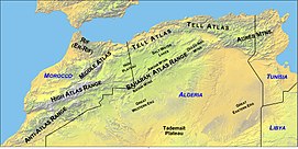
High Atlas, also called the Grand Atlas Mountains (Arabic: الاطلس الكبير; French: Haut Atlas; Berber: ⴰⴷⵔⴰⵔ ⵏ ⴷⵔⵏ) is a mountain range in central Morocco in Northern Africa.
The High Atlas rises in the west at the Atlantic Ocean and stretches in an eastern direction to the Moroccan-Algerian border. At the Atlantic and to the southwest the range drops abruptly and makes an impressive transition to the coast and the Anti-Atlas range. To the north, in the direction of Marrakech, the range descends less abruptly.
The range includes Jbel Toubkal, which at 4,167 m is the highest in the range and lies in Toubkal National Park. The range serves as a weather system barrier in Morocco running east-west and separating the Sahara from the Mediterranean and continental zones to the north and west. In the higher elevations of the massif, snow falls regularly, allowing winter sports. Snow lasts well into late spring in the High Atlas, mostly on the northern faces of the range. On the Western High Atlas, there is Oukaïmeden, one of three main ski stations in Morocco.
The High Atlas forms the basins for a multiplicity of river systems. The majority of the year-round rivers flow to the north, providing the basis for the settlements there. A number of wadis and seasonal rivers terminate in the deserts to the south and plateaux to the east of the mountains.
The High-Atlas Mountains are inhabited by Berbers, who live from agriculture and pastoralism in the valleys. In the steppe zone of the High-Atlas, where precipitations are low, the locals created a smart technique in managing the low precipitations and the weak soil. They turn the rather semi-arid lands into fertile valleys called locally by Agdal (garden in Berber). This technique has intrigued many Western agriculturalists, in which they were impressed by the high efficiency of this agricultural system. Many scientists, particularly French scientists, make yearly expeditions to observe the community and their living system.
...
Wikipedia

