Grafenried, Switzerland
| Grafenried | ||
|---|---|---|
| Former municipality of Switzerland | ||

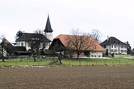
Grafenried village and church
|
||
|
||
| Coordinates: 47°5′N 7°31′E / 47.083°N 7.517°ECoordinates: 47°5′N 7°31′E / 47.083°N 7.517°E | ||
| Country | Switzerland | |
| Canton | Bern | |
| District | Bern-Mittelland | |
| Area | ||
| • Total | 4.7 km2 (1.8 sq mi) | |
| Elevation | 520 m (1,710 ft) | |
| Population (Dec 2011) | ||
| • Total | 980 | |
| • Density | 210/km2 (540/sq mi) | |
| Postal code | 3308 | |
| SFOS number | 0539 | |
| Surrounded by | Etzelkofen, Fraubrunnen, Iffwil, Jegenstorf, Zauggenried | |
| Website |
www SFSO statistics |
|
Grafenried is a former municipality in the Bern-Mittelland administrative district in the canton of Bern in Switzerland. On 1 January 2014 the former municipalities of Grafenried, Büren zum Hof, Etzelkofen, Limpach, Mülchi, Schalunen and Zauggenried merged into the municipality of Fraubrunnen.
Grafenried is first mentioned in 1258 as Gravenriet. In 1262 it was mentioned as Riede.
The oldest trace of a settlement is a Hallstatt era grave mound at Eichberg. The remains of what may have been a Roman era farm as well as a late medieval abandoned village were discovered at Wille/Wittenberg. During the Middle Ages the village, court and church were owned by the Counts of Thierstein. In the 13th century Fraubrunnen Abbey acquired the entire village. It remained under the Abbey's control until Bern adopted the Protestant Reformation, secularized the Abbey and took all the Abbey's lands in 1528. Under Bernese control, Grafenried became part of the bailiwick of Fraubrunnen, which was part of the court of Zollikofen.
The first church in the village was built in the 7th or 8th century. The aisleless church was built above a post-Roman tomb outside the village on the road to Fraubrunnen. The village bought the patronage rights to the church from the Abbey in 1258. In 1535 it became the parish church for the municipality. The current church was built in 1748.
...
Wikipedia


