Gräfenroda
| Gräfenroda | ||
|---|---|---|

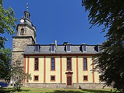
St Lawrence Church
|
||
|
||
| Coordinates: 50°44′56″N 10°48′44″E / 50.74889°N 10.81222°ECoordinates: 50°44′56″N 10°48′44″E / 50.74889°N 10.81222°E | ||
| Country | Germany | |
| State | Thuringia | |
| District | Ilm-Kreis | |
| Municipal assoc. | Oberes Geratal | |
| Government | ||
| • Mayor | Frank Fiebig (The Left) | |
| Area | ||
| • Total | 23.32 km2 (9.00 sq mi) | |
| Elevation | 400 m (1,300 ft) | |
| Population (2015-12-31) | ||
| • Total | 3,232 | |
| • Density | 140/km2 (360/sq mi) | |
| Time zone | CET/CEST (UTC+1/+2) | |
| Postal codes | 99330 | |
| Dialling codes | 036205 | |
| Vehicle registration | IK | |
| Website | www.graefenroda.de | |
Gräfenroda is a municipality in the Ilm-Kreis district, in Thuringia, Germany. It is the administrative seat of the Verwaltungsgemeinschaft Oberes Geratal.
The municipal area stretches along the valley of the Wilde Gera river and its Lütsche tributary, northeast of the Thuringian Forest mountain range and the Rennsteig ridge. The Lütsche Reservoir built in 1935-38 is located west of the settlement. The municipality has access to the Bundesautobahn 71 near the Rennsteig Tunnel at Gräfenroda junction, about 3 km (1.9 mi) to the southeast.
With a population of about 3200, Gräfenroda is the district's fourth-largest municipality, though without town privileges.
Gräfenroda was first mentioned in a 1290 deed, located on an important trade route from Arnstadt to Suhl. From the early 14th century onwards, the local estates were held by the Thuringian noble house of Schwarzburg. From 1640 half of the estates were in possession of the Ernestine dukes of Saxe-Gotha, while the remaining Schwarzenburg parts from 1716 were ruled within the principality of Schwarzburg-Sondershausen. The local population was largely involved in agriculture and forestry, but also in copper, silver and lead mining, as well as in glass production.
...
Wikipedia


