Gospel Hump Wilderness
| Gospel Hump Wilderness | |
|---|---|
|
IUCN category Ib (wilderness area)
|
|

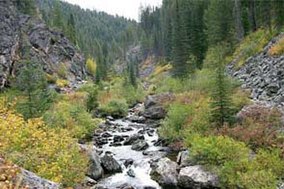
Crooked Creek in Gospel Hump Wilderness
|
|
| Location | Idaho County, Idaho, United States |
| Nearest city | Elk City, Idaho |
| Coordinates | 45°33′57″N 115°46′32″W / 45.56583°N 115.77556°WCoordinates: 45°33′57″N 115°46′32″W / 45.56583°N 115.77556°W |
| Area | 205,796 acres (832.83 km2) |
| Established | February 24, 1978 |
| Governing body | U.S. Forest Service |
The Gospel Hump Wilderness is a federally-protected wilderness area that covers 205,796 acres (83,283 ha) of the state of Idaho. Managed by the U.S. Forest Service in the U.S. Department of Agriculture, it received wilderness designation on February 24, 1978 through the passage of the Endangered American Wilderness Act and is part of Nez Perce National Forest. As part of the National Wilderness Preservation System, the Gospel Hump Wilderness is an area where human development and use are restricted and people are to remain only visitors.
The Nez Perce people lived in Idaho as early as 6000 BCE, and the area that is now the Gospel Hump Wilderness was used by them long before the arrival of settlers. In 1861 gold was discovered in Florence, Idaho, just outside the wilderness's boundary. A quartz vein at the base of Buffalo Hump was discovered in 1898, which sparked a gold rush before mining subsided in 1903. Remnants of mines and other structures remain in the wilderness. The wilderness was formally established on February 24, 1978 when Congress passed Public Law 95-237.
When the Gospel Hump Wilderness is combined with the adjacent Frank Church-River of No Return Wilderness Area and the surrounding unprotected inventoried roadless area, it is part of a 3,300,000-acre (13,000 km2) wilderness-roadless area complex. To the north of the Frank Church-River of No Return Wilderness Area lies the Selway-Bitterroot Wilderness Area. These two large Wilderness areas are separated only by a single dirt road (the Magruder Corridor), connecting Red River, Idaho to Darby, Montana. Negating the Magruder Corridor, the Selway-Bitterroot, Gospel Hump and Frank Church-River of No Return Wilderness Areas constitute the largest intact piece of wildland in the United States outside of Alaska.
...
Wikipedia

