Gonarezhou National Park
| Gonarezhou National Park | |
|---|---|
|
IUCN category II (national park)
|
|

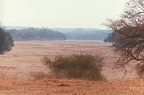
Buffalo Bend on the Mwenezi River, Gonarezhou National Park, Zimbabwe
|
|
| Location | Chiredzi (District), Zimbabwe. |
| Coordinates | 21°40′S 31°40′E / 21.667°S 31.667°ECoordinates: 21°40′S 31°40′E / 21.667°S 31.667°E |
| Area | 5,053 km2 (1,951 sq mi) |
| Established | 1975 |
Gonarezhou National Park is a national park located in south-eastern Zimbabwe. It is situated in a relatively remote corner of Masvingo Province, south of Chimanimani along the Mozambique border. Owing to its vast size, rugged terrain and its location away from main tourist routes, large tracts of Gonarezhou remain as pristine wilderness.
At 5,053 km2 Gonarezhou is the country’s second largest game reserve after Hwange National Park. Gonarezhou is a Shona name meaning "elephant's tusk." It forms part of the Great Limpopo Transfrontier Park, a peace park that links Gonarezhou with the Kruger National Park in South Africa and the Limpopo National Park in Mozambique. Animals can move freely between the three sanctuaries.
The north-eastern end of the park is located within the Zambezian and Mopane woodlands, while the southwest is located within the Southern Africa bushveld ecoregion.
The Gonarezhou National Park was formed in 1975, by uniting former hunting areas and tsetse fly control corridors.
The park was closed to the public during the Rhodesian War and again during much of the Mozambique civil war but was re-opened in 1994.
The park is part of the international Great Limpopo Transfrontier Park.
The park is a lowveld region of baobabs, scrublands and sandstone cliffs.
...
Wikipedia
