Golf Manor, Ohio
| Golf Manor, Ohio | |
|---|---|
| Village | |

Houses on Hammel Avenue
|
|
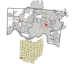
 Location in Hamilton County and the state of Ohio. |
|
| Coordinates: 39°11′14″N 84°26′47″W / 39.18722°N 84.44639°WCoordinates: 39°11′14″N 84°26′47″W / 39.18722°N 84.44639°W | |
| Country | United States |
| State | Ohio |
| County | Hamilton |
| Area | |
| • Total | 0.57 sq mi (1.48 km2) |
| • Land | 0.57 sq mi (1.48 km2) |
| • Water | 0 sq mi (0 km2) |
| Elevation | 659 ft (201 m) |
| Population (2010) | |
| • Total | 3,611 |
| • Estimate (2012) | 3,591 |
| • Density | 6,335.1/sq mi (2,446.0/km2) |
| Time zone | Eastern (EST) (UTC-5) |
| • Summer (DST) | EDT (UTC-4) |
| ZIP code | 45237 |
| Area code(s) | 513 |
| FIPS code | 39-30786 |
| GNIS feature ID | 1048793 |
Golf Manor is a village in Hamilton County, Ohio, United States. It is surrounded nearly completely by the Pleasant Ridge and Roselawn neighborhoods of Cincinnati. The population was 3,611 at the 2010 census.
Golf Manor was laid out by property developers in the 1920s.
Golf Manor is located at 39°11′14″N 84°26′47″W / 39.18722°N 84.44639°W (39.187109, -84.446365).
According to the United States Census Bureau, the village has a total area of 0.57 square miles (1.48 km2), all land.
As of the census of 2010, there were 3,611 people, 1,614 households, and 897 families residing in the village. The population density was 6,335.1 inhabitants per square mile (2,446.0/km2). There were 1,837 housing units at an average density of 3,222.8 per square mile (1,244.3/km2). The racial makeup of the village was 24.3% White, 72.6% African American, 0.1% Native American, 0.2% Asian, 0.4% from other races, and 2.3% from two or more races. Hispanic or Latino of any race were 1.2% of the population.
...
Wikipedia
